
![]()
FIELD WALKING
ANALYSIS OF RESULTS
18TH CENTURY
Skip to each of these headings in the text below:
Fabric types
Correlation analysis
Distribution
Coarse earthenware
General Enclosure
Conclusions
FABRIC TYPES
Documentary evidence that can be used to date fabric types that may have been in use during the late 17th and 18th centuries is variable in quality and in some cases gives long, overlapping date ranges that reduce their utility. The dating information available is shown in Table 3.4.
Table 3.4. Date ranges from documentary sources for 17th and 18th century fabric types
| FABRIC TYPE | DATE RANGE |
| Black Ware |
Late 16-early 18C |
| Light-bodied Black Ware |
Mid 17-early 18C |
| Coarse Black Ware |
Mid 16-18C |
| Tin glazed ware |
17- mid 18C |
| Martincamp flask (Ticknall) |
mid 17C |
| Slip-trailed Slipware |
17-18C |
| ‘Staffordshire’ Slipware Late |
17-18C |
| Black Slipware Late |
17-18C |
| Mottled Ware Late |
17-mid18C |
| Nottingham Salt-glaze Stoneware Late |
17-18 C |
| Coarse earthenware |
|
| Glazed Red Earthenware |
Early 16-mid17C |
| Vitrified Glazed Coarse Earthenware |
Late 17-18C |
| Pink-bodied Black Glazed Coarse Earthenware |
Late 17-18C |
| Brown Glazed Slip-coated Coarse Earthenware |
Late 17-18C |
| Brown Glazed Coarse Earthenware |
Late 17-19C |
| Red-bodied Black Glazed Coarse Earthenware |
Late 18-19C |
| Light-bodied Coarse Earthenware |
Late 18-19C |
| Yellow Coarse Earthenware | 18C (possibly)-19C |
The best dated among these are Nottingham Salt-glaze Stoneware, which came into production in c1688 and lasted for about 100 years (Henstock, in prep). Ticknall copies of Martincamp flasks are tied to the mid 17th century, but there are too few of these to help in any analysis. While some of the Mottled Ware found in Bingham can be matched to wares made in Ticknall, much of it has not and is likely to be from Staffordshire. According to Deborah Ford (1999) Mottled Ware production in Staffordshire is confined to the first half of the 18th century.
The remaining fabrics are less precisely dated. Slip-trailed Slipware was at its most popular in the second half of the 17th century, during the reign of Charles II, but the technique persisted and ornamental pieces made in the 18th century were sometimes part slip-trailed. Feathered or combed slipware, though made in the 17th century, was very popular in the first half of the 18th century when press-moulded dishes in this style were made both in Ticknall and Staffordshire. The style continued in use well after this in some parts of the country. The sherds from Bingham are likely to be from Ticknall and Staffordshire.
Among other fabric types Black Slipware does not seem to have been made in Ticknall and until its provenance is known cannot be reliably used. Black Ware or Midland Black Ware, light-bodied Black Ware, Coarse Black Ware were all matched with Ticknall fabrics, but their production has not been reliably dated there.
The most abundant of all post-medieval fabrics are the coarse earthenware types. The three that make up 88% of the total coarse earthenware were closely matched with fabrics from Ticknall, but have not been given date ranges there.
CORRELATION ANALYSIS
Correlation analysis was used in an attempt to improve the reliability of dating. The basic assumption that was tested is that wares made at the same time will appear in the fields at the same time at the same levels of relative abundance as when they were manufactured. Several pairs of fabric types have been tested this way using the Excel 95 line plotting facility. The basic sample unit used is the field as shown on the 1776 map. It is thought that the majority of these fields would have the same boundaries as when the parish was enclosed in 1680-1690 or soon after. In each line plot one of the fabric types was normalised to show gradual increase in number from the left.
The method was tested first on coarse earthenware fabric types because their date ranges are the least well documented. The two main coarse earthenware fabric types are Red-bodied Black Glazed and Pink-bodied Black Glazed Coarse Earthenware, which together make up 82% of the total coarse earthenware. Next is Vitrified Glazed Coarse Earthenware, which make up 6%. All three of these were matched among the collection of finds from kiln sites in Ticknall, which suggests that most of the Bingham sherds are from wares made in Ticknall. Although Spavold and Brown (2005) do not identify the fabric types produced by each potter in Ticknall, they point out that from the late 17th century the Ticknall potteries concentrated on making cheap kitchen and dairy wares, including butter pots, and did not try to compete with Stoke-on-Trent potteries in the manufacture of high quality wares. They also show that while some of the potteries continued in operation to 1886, there is a big fall-off in production after 1780.
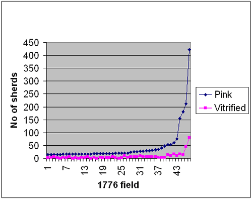
Figure 3.44. Excel line plot of Pink-bodied Black Glazed Coarse Earthenware and Vitrified Glazed Coarse Earthenware. This shows the number of finds per 1776 field increasing from left to right, normalised against pink-bodied coarse earthenware. Fields with 0 and 1 find per hectare are excluded.
Microscopic and macroscopic evidence suggests that the Pink-bodied Black Glazed Coarse Earthenware and Vitrified Glazed Coarse Earthenware were different from each other in form and in the temperature of firing, but had similar composition of temper and it was concluded that they were probably made at the same time and possibly even at the same potteries. The line plots (Figure 3.44) showed an almost perfect correlation. The difference in the gradients between the two curves reflects the ratio of 6:1, which is the ratio by number (not weight) of sherds of pink-bodied to vitrified coarse earthenware within the whole collection. This gave an indication that for a working hypothesis the basic assumption is correct. Several other pairs were then tested, but none were as convincing. These include Mottled Ware versus ‘Staffordshire’ Slipware (Figure 3.47) and both of these against 18th century Nottingham Salt-glaze Stoneware (Figure 3.45 and 3.46). In these three plots the values 0 and 1 in the normalised curve have been excluded. In all three the curves were similarly shaped, but on a field-by-field basis the relative proportions were not consistent,

Figure 3.45. Excel line plots of slipware and stoneware. The stoneware graph is normalised to increase from left to right and the values for 0 and 1 per field have been excluded.
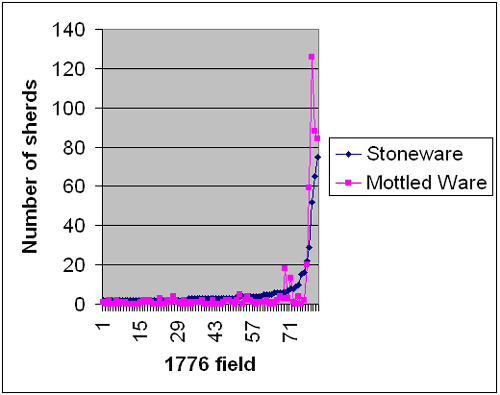
Figure 3.46. Excel line plots of Stoneware and Mottled Ware. Values of 0 and 1 find per field of stoneware are excluded. Stoneware is normalised to increase from left to right
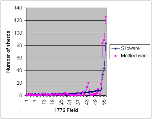
Figure 3.47. Excel line plots of “Staffordshire” Slipware and Mottled Ware showing number of finds per 1776 field. Slipware is normalised to increase from left to right.
Other fabrics tested include Yellow Coarse Earthenware. There is no documentary evidence of age for this fabric. Plotting it against 18th century fabrics such as ‘Staffordshire’ slipware produces a relationship such as in Figure 3.48, in which it is clear that the gradients of the two curves are not the same.
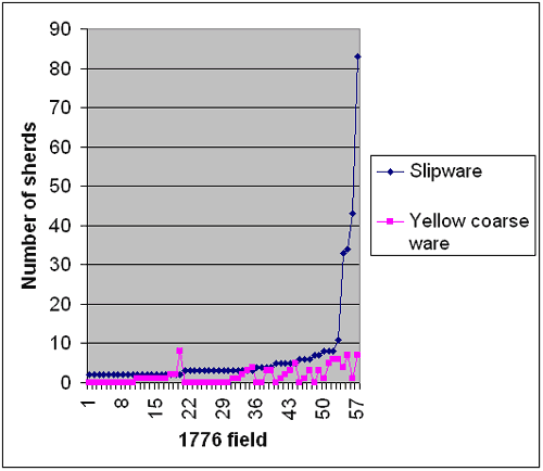
Figure 3.48. Excel line plots of Yellow Coarse Earthenware and slipware. The slipware plot has been normalised to increase from left to right and the values for 0 and 1 have been excluded.
It seems that the close temporal relationship between the pink-bodied and vitrified coarse earthenware suggested by analysis of the fabric is confirmed by correlation analysis, but the relationships between the three main dateable 18th century fabrics are not so clear. However, in comparison, the line plot for Yellow Coarse Earthenware does not show any form of correlation with any 18th century fabric types.
Reasons for the lack of clarity in the Excel line plots of the undoubted 18th century fabric types are probably varied, but must include factors such as whether the sherds were delivered to the fields in farmyard manure or night soil, how frequently the fields were manured, whether or not the farmers employed long-period rotations between arable and pasture, whether or not the sherds were tableware, kitchenware or dairy ware, whether they were from high quality or cheap wares and if any of these factors meant that they were delivered to the fields at different times. These will all have an influence on their eventual distribution. There is also a question about the validity of using the 1776 field as the sample unit. Compared with the 100 metre grid distribution plots (see later) the Excel line plots for Mottled Ware, ‘Staffordshire’ Slipware and 18th century stoneware based on the 1776 fields were less informative. This seems to suggest that this method for testing date ranges would work best if the sample unit were small and uniformly sized.
It is clear that further research into this method is necessary before it can be used to generate reliable results.
DISTRIBUTION
The most striking fact that emerges from the distribution plots of the post medieval fabric types (excluding coarse earthenware) is that the highest densities for nearly all of the late 17th and 18th century types fall within the area that in 1776 was called Far Little Moor and Meadow Moor, which equate to modern fields 0208, 0306, 0409 and 0507 on Holme Farm and is the main part of West Moor in 1586 (Figure 3.49). In 1586 these fields were common grazing and despite general enclosure at the end of the 17th century they seemed to have remained common grazing in 1776. To give two examples to illustrate the difference between these fields and the rest in the parish the average density per 1776 field of Coarse Black Ware in the parish, excluding these four fields, is 1.8 finds per hectare. In these four fields it is 59 finds per hectare. For Mottled Ware the respective figures are 1.5 and 89 finds per hectare.
Figure 3.49. Far Little Moor and Meadow Moor as in 1776 with the modern field boundaries imposed on them. These four fields are given numbers in the 1776 terrier, but there appear not to have been any boundaries established.
Far Little Moor and Meadow Moor
Arguments have been presented that in the Tudor-Stuart period the two eastern modern fields, 0409 and 0507 (equivalent to Meadow Moor in 1776) were used for a village dump (see West Moor). Densities for pre-18th century fabric types in the two modern fields on the west (0208 and 0306) are all low. High values for 18th century stoneware, Mottled Ware and ‘Staffordshire’ Slipware, however, are found on both sides of the track that divides Far Little Moor from Meadow Moor (Figure 3.50, 3.51 and 3.52). It is suggested that the best explanation for these high densities of 18th century material is that the fields on the east of the track continued to be used for dumping village rubbish into the 18th century, while the fields to the west came into use for dumping only in the late 17th century.
Figure 3.50. A grid map showing the distribution of “Staffordshire” Slipware on a base of the 1776 fields. The four field numbers in the north are land parcels that are listed in the terrier, but there were no boundaries shown on any maps.
Figure 3.51. A grid map showing the distribution of 18th century Nottingham brown stoneware on 1776 fields. The four field numbers in the north are land parcels that are listed in the terrier, but there were no boundaries shown on any maps.
Figure 3.52. A grid map showing the distribution of Mottled Ware on the 1776 fields. The four field numbers in the north are land parcels that are listed in the terrier, but there were no boundaries shown on any maps.
The clay pipes in these fields are informative. There are no definitively 17th century dated bowls in Far Little Moor. The earliest dated pipe has a range 1680-1720. However, there are 44 dated bowls with a range through the 18th century and 18 that give 19th century dates. All of these pre-date 1880. This seems to suggest that dumping to the west of the track did not start before 1680 and was possibly finished by 1880.
On the east of the track in Meadow Moor, by contrast, there are 34 bowls with dates that range through the 17th century and 45 with dates that span the 18th century. There are only 5 that were definitely made after 1800.
Using the clay pipe data in conjunction with the pottery data it seems that dumping took place first east of the track during the time that Cistercian Ware was used in Bingham, which is late 15th to early in the 16th century, and continued there until the end of the 18th century. On the west of the track, dumping began no earlier than 1680 and continued until the late19th century.
An attempt to use the clay pipe data to establish a date for the first appearance of late 17th and 18th century fabric types about which information on date ranges is poor proved inconclusive. All fabric types except Light-bodied Black Ware are found on both sides of the track, which means that using distribution information alone it is not possible to set a date for the first appearance of any of the fabrics. However, the 100 metre grid plots (Figure 3.50, 3.51 and 3.52) show that some of the highest value 100-metre squares for Mottled Ware, ‘Staffordshire’ Slipware and Nottingham Salt-glaze Stoneware are coincident and are on both sides of the track. This must place the Mottled Ware and ‘Staffordshire’ Slipware firmly in the 18th century with the stoneware. The Coarse Black Ware (Figure 3.53) also has high value squares on both sides of the track, but not all of them are coincident with the other three fabrics. This fabric type may have evolved in Ticknall either at the same time or just after Cistercian Ware in the late 15th or early 16th century. The distribution plots, however, shows that whatever the start date for this fabric type it was certainly in use during the 18th century.
Figure 3.50. A grid map showing the distribution of “Staffordshire” Slipware on a base of the 1776 fields. The four field numbers in the north are land parcels that are listed in the terrier, but there were no boundaries shown on any maps.
Figure 3.51. A grid map showing the distribution of 18th century Nottingham brown stoneware on 1776 fields. The four field numbers in the north are land parcels that are listed in the terrier, but there were no boundaries shown on any maps.
Figure 3.52. A grid map showing the distribution of Mottled Ware on the 1776 fields. The four field numbers in the north are land parcels that are listed in the terrier, but there were no boundaries shown on any maps.
Figure 3.53. A grid map showing the distribution of Coarse Black Ware on the 1776 fields. The four field numbers in the north are land parcels that are listed in the terrier, but there were no boundaries shown on any maps.
East Meadow
On the 1776 map the area that was East Meadow on the 1586 conjectural map is divided up into a number of closes and is not common or shared grazing. In the 16th-17th century this area shows an unusually high density of pottery sherds, particularly Yellow Ware, which it was argued could indicate either that it was used as a dump or the sherds were spread with farmyard manure when parts of the area were used in an arable/pasture rotation in the 17th century. This same area shows slightly elevated densities of 18th century fabric types, but there is no coincidence of high spots on the 100-metre grid plots (Figures 3.50, 3.51 and 3.52). Interestingly, some of the best preserved 17th century clay pipe bowls were found in this field, but there are no 18th century bowls. It is unlikely that any of the 18th century high spots indicate dumping in the same way as on the common land in Far Little Moor and Meadow Moor at this time. However, field notes for modern fields 1999 and 1803 record small areas of pottery and rubble, including brick, stone, tiles and glass, which seem to suggest that there were small dumps there. The origin of the dumps is not clear, but there is one interesting possibility. Some of the high spots on the 100-metre grid plots lie along a northward extension of Brickyard Lane. It is known from the OS map that the lane extended as far north as the railway line in 1883 and it is speculated that it may have gone further north and been an access to fields now on the north side of the railway line in the 18th century. If so these small dumps could have been filling potholes in the track. Spavold and Brown (2005) found records of cartloads of broken pots being sold to fill potholes in local roads around Ticknall. A second possibility is that the pottery was used to improve grassland. Lowe (1798) refers to a farmer in the Vale of Belvoir who used crushed skerry at the rate of 5 tons an acre to “improve grass ground”. This has been suggested as one of the explanations for the spread of 17th century pottery in this area. However, the absence from these fields of 18th century clay pipes, which is unusual, might suggest that broken pottery was acquired specifically for this purpose rather than skerry and makes a better case for the 18th century than for the 17th century.
Other locations
One 100-metre square in East Moor (modern field 1002) has slightly elevated levels of Mottled Ware and Coarse Black Ware (Figure 3.52 and 3.53). Similar levels of 18th century stoneware are present in the next square east. These areas are close to the track that leads from Cogley Lane to Holme Farm and it may represent a dump of some kind.
Figure 3.52. A grid map showing the distribution of Mottled Ware on the 1776 fields. The four field numbers in the north are land parcels that are listed in the terrier, but there were no boundaries shown on any maps.
Figure 3.53. A grid map showing the distribution of Coarse Black Ware on the 1776 fields. The four field numbers in the north are land parcels that are listed in the terrier, but there were no boundaries shown on any maps.
Everywhere else in the parish the densities are low and no other high points for any of the 18th century wares are coincident. This is consistent with the distribution probably being the result of manuring. Although there are many 1776 fields with no ‘Staffordshire’ Slipware or Mottled Ware or stoneware, there are practically none lacking all three. This even applies to the areas that on the distribution of Yellow Ware were probably pasture throughout the 17th century. The reason for this might be related to changes in land management in the 18th century. According to Lowe (1798) the enclosed parts of the Vale of Belvoir was a mixture of arable and pasture with a little dairying. Different farmers had tried different rotational regimes, some of which involved following two or three years of arable with two or three years of pasture before returning to arable. He did not say if this was practised in Bingham, but this could explain the different patterns of distribution of the three 18th century fabric types observed. The presence of 18th century fabric types in the large area of the south eastern part of the parish that was pasture in the 17th century suggests that a rotational scheme was practised even here. There is some support for this in information from the estate survey of 1776 in which parts of this area are listed as under arable agriculture. The total amount of 18th century material here is small, suggesting that it remained predominantly pasture for most of this century.
COARSE EARTHENWARE
The distribution plots for all the coarse earthenware fabric types show high densities in the four modern fields on Holme Farm, 0208, 0306, 0409 and 0507, that have been shown to be the sites of the village dumps. However, only pink-bodied, red-bodied, vitrified and brown-glazed coarse earthenware have densities in the highest of the five categories shown in the plots only in these fields (Figures 3.54, 3.55, 3.56 and 3.57).
Figure 3.54. A grid map superimposed on the 1776 fields showing the distribution of Red-bodied Black Glazed Coarse Earthenware. The four field numbers in the north are land parcels that are listed in the terrier, but there were no boundaries shown on any maps.
Figure 3.55. A grid map superimposed on the 1776 fields showing the distribution of Pink-bodied Black Glazed Coarse Earthenware. The four field numbers in the north are land parcels that are listed in the terrier, but there were no boundaries shown on any maps.
Figure 3.56. A grid map superimposed on the 1776 fields showing the distribution of Vitrified Glazed Coarse Earthenware. The four field numbers in the north are land parcels that are listed in the terrier, but there were no boundaries shown on any maps.
Figure 3.57. A grid map superimposed on the 1776 fields showing the distribution of Brown-glazed Coarse Earthenware. The four field numbers in the north are land parcels that are listed in the terrier, but there were no boundaries shown on any maps.
On Holme Farm, the highest density 100-metre squares of Vitrified Glazed Coarse Earthenware are exclusively on the east of the track that divides the fields and which other evidence suggests ceased to be used as a dump after the late 18th century. The other fabric types have high values on both sides of the track. In Figure 3.82 the finds densities are shown as ratios and it is evident that on the east of the track and the northern half of field 0208 on the western side there is mostly pink-bodied coarse earthenware. Detailed examination of the 1883 field 0208A shows that it probably fell out of use as a place for the village dump in the mid 19th century. The 1883 field 0208B, however, and the whole of modern field 0306 to the south of 0208B appeared to continue in use for dumping until around 1870. These fields show a ratio between red-bodied and pink-bodied coarse earthenware of 50:50.
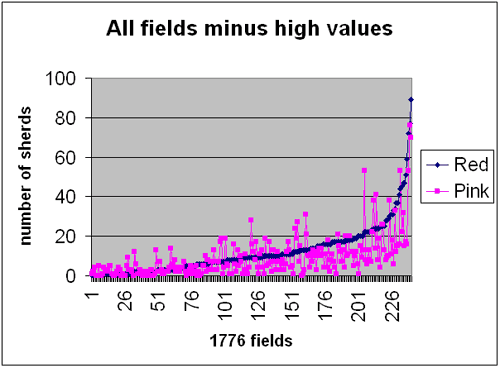
Figure 3.58. Excel line plots for red-bodied and pink-bodied coarse earthenware. All fields are included except those with values above 100 finds per field. The red-bodied plot has been normalised to increase from the left to the right.
As can be seen on the Excel line plots (Figure 3.58), the overall shapes of the curves for the red-bodied and pink-bodied coarse earthenware are the same, but there is no close relationship on a field by field basis. Also, the grid plot (Fig 3.54) shows moderately high densities of red-bodied elsewhere in the parish, while the ratio map Figure 3.82 shows a number of fields around the parish with only red-bodied coarse earthenware. There are no moderately high value grid squares for pink-bodied (Figure 3.55) outside the dumps, but on the ratio map fields with only pink bodied are widespread. For Vitrified Glazed Coarse Earthenware there is one moderately high grid square outside the area of the dumps (Figure 3.56).
Figure 3.54. A grid map superimposed on the 1776 fields showing the distribution of Red-bodied Black Glazed Coarse Earthenware. The four field numbers in the north are land parcels that are listed in the terrier, but there were no boundaries shown on any maps.
Figure 3.55. A grid map superimposed on the 1776 fields showing the distribution of Pink-bodied Black Glazed Coarse Earthenware. The four field numbers in the north are land parcels that are listed in the terrier, but there were no boundaries shown on any maps.
Figure 3.56. A grid map superimposed on the 1776 fields showing the distribution of Vitrified Glazed Coarse Earthenware. The four field numbers in the north are land parcels that are listed in the terrier, but there were no boundaries shown on any maps.
Some tentative conclusions can be reached from the distribution of these three fabric types.
- The predominance of red-bodied coarse earthenware in the parts of the fields in Holme Farm that were used for dumping until about 1870 suggests that while this fabric type may have been manufactured in the 18th century, it was predominantly a 19th century fabric.
- A similar conclusion can be reached about the Brown-glazed Coarse Earthenware, though this is more of a heterogeneous group than the red-bodied coarse earthenware (Figure 3.57).
- The pink-bodied coarse earthenware has more high points in the parts of the dump sites that went out of use in the late 18th or early 19th century suggesting that it was primarily an 18th century fabric, but that manufacture may have continued into the 19th century.
- The absence of vitrified coarse earthenware high points on the west of the track suggests that this fabric type was confined to the 18th century.
Figure 3.57. A grid map superimposed on the 1776 fields showing the distribution of Brown-glazed Coarse Earthenware. The four field numbers in the north are land parcels that are listed in the terrier, but there were no boundaries shown on any maps.
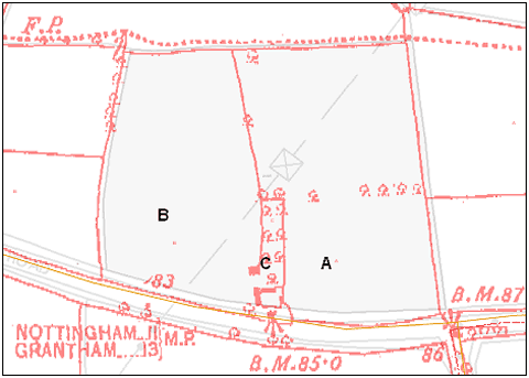
Figure 3.59. Modern field 2495 on Brocker Farm, showing the smaller component fields in 1883.
There is limited support for these conclusions in field 2495 (Figure 3.59). In 1776 this field was made up of two smaller fields, but the tithe map of 1841 shows an orchard and house to have been added. By 1922 the house had gone, but the orchard remained. Although the sample size is small there are only red-bodied coarse earthenware sherds in the area that was orchard and they are close to the debris that marked the site of a demolished house. It is thought that they probably arrived there after the house was built, which would date the deposition of the red-bodied coarse earthenware as after 1776.
The population sizes for the other coarse ware fabric types are low with only Brown Glazed Slip-coated Coarse Earthenware exceeding 3 finds per hectare. All three have high points in the dump fields, but none have high points exclusively in those fields (Figures 3.60, 3.61 and 3.62). Brown Glazed Slip-coated Coarse Earthenware (Figure 3.62), which has a fabric that resembles the pink-bodied coarse earthenware, occurs only on the eastern side of the track. Its distribution correlates most closely with Vitrified Glazed Coarse Earthenware, which suggests that it is an 18th century fabric. The Yellow Coarse Earthenware and the Light-bodied Coarse Earthenware, on the other had have their highest-density squares only on the western side, where dumping continued until the late 19th century.
Figure 3.60. A grid map superimposed on the 1776 fields showing the distribution of Yellow Coarse Earthenware. The four field numbers in the north are land parcels that are listed in the terrier, but there were no boundaries shown on any maps.
Figure 3.61. A grid map superimposed on the 1776 fields showing the distribution of Light-bodied Coarse Earthenware. The four field numbers in the north are land parcels that are listed in the terrier, but there were no boundaries shown on any maps.Figure 3.62. A grid map superimposed on the 1776 fields showing the distribution of Brown-glazed slip coated Coarse Earthenware. The four field numbers in the north are land parcels that are listed in the terrier, but there were no boundaries shown on any maps.
Several of the fabric types appear to have high concentrations in the fields of East Meadow. This area has been distinctive since the 16th century and various reasons for the local concentrations of pottery sherds have been put forward. These include small dumps of household waste, pothole fill along a track, the use of broken pottery to improve the soil in grassland and spread in manure while under arable cultivation. The persistence of concentrations of pottery above the norm in this area for the period 16th to 19th centuries suggests that some form of unusual activity was taking pace here and that at different times all parts of East Meadow were affected. Though all four explanations are valid and may have happened, it is likely that in the wide spread of pot sherds in the18th and 19th centuries is best explained by using them in manure to improve the heavy clay soil for arable usage.
GENERAL ENCLOSURE
Analysis of the field walked data for the northern part of the parish suggests that it was probably enclosed piecemeal over several centuries. Some field boundaries can be identified that date from as early as the 12th century and others date from the 15th or 16th centuries. Figure 3.63 shows these boundaries, but also highlights some that no longer exist, but which appear from their shape on the 1883 OS map also to be early. The earliest church glebe ‘terriers’ (surveys of church-owned land) for 1687 and 1693 list two closes – the Butt Close and the High Close, probably Parson’s Hill – described as ‘well and distinctly fenced with ditches, pales, or hedges and stoops [posts] with rails’ (NA, DR glebe terriers), although both of these were noted as demesne land and probably already enclosed at the time of the 1586 survey.
The date of the enclosure of the arable open fields is not recorded. The hedgerow survey identified some mixed hedges that possibly date to the 15th or 16th centuries in West Field, but in the other arable fields the hedges are mostly hawthorn dominant and there is nothing to suggest that any are older than late 17th century.
Yelling (1977) made the distinction between piecemeal and general enclosure. Piecemeal enclosure is a gradual process involving a series of private agreements, which led to the amalgamation and subsequent walling or hedging of groups of contiguous open-field strips. It usually made no impact on the areas of common grazing. General enclosure was a process involving the whole community of landowners acting in concert to enclose the whole parish or township in one go. This could happen ‘by unity of possession’ where the whole of the estate was owned by a single landowner, and was common in the 15th and 16th centuries, or ‘by formal agreement’ where there was more than one proprietor. Enclosure by ‘formal agreement’ was common in the 16th century, but especially characteristic of the 17th century. By the 17th century enclosures were sometimes ratified by a decree in the Courts of Chancery. However, from about 1750 onwards it became normal for enclosure to be achieved through individual private Acts of Parliament, and numerous parishes in Nottinghamshire were enclosed under this system.
Enclosure was a massive undertaking, having a profound social effect on a community. It involved all the open fields being broken up and land reallocated to landowners in compact hedged blocks in proportion in size to their original holdings (but reduced in area to cover the costs of the process). It would have been carried out by professional land surveyors and often took two or three years to complete.
In the 17th century there were two major landowners in Bingham. The Earl of Chesterfield owned most of the parish, but the Porter family had a significant holding. In addition, other, small, freeholders with smallholdings in the village had strips in the open fields.
In the Vale of Belvoir around Bingham the majority of parishes were enclosed by Parliamentary Acts in Georgian times. In Bingham unfortunately no definite evidence has yet been found of the date when the fields were enclosed. The process obviously took place between 1586 – the date of the manorial survey– and another survey of the Earl of Chesterfield’s estates drawn up in 1776 (NA, M 1874), which is accompanied by a series of maps. These maps clearly show that by 1776 most of the farmland was divided into the modern system of closes that in essence survives today, with the exception of some of the common pasture (see below).
John Throsby (1797) in his History of Nottinghamshire stated about Bingham, “lordship contains about 3000 acres of land inclosed upwards of 100 years.” This would put the date of enclosure at around 1690. Another reference, however, is in Lowe (1798). He lists Bingham as having been enclosed within 20 years in his Appendix VII. Whether he meant the full, general enclosure or the completion of the enclosure process is not known.
There is support for the late 17th century date in the names of some of the fields. Both the Chesterfield Estate maps of 1776 and the Bingham Tithe Map of 1841 show many closes bearing the name ‘plotts’ (eg. Toothill Plotts), which is a 17th century word for an allotment or enclosure and is not found in the 1586 survey. The probate inventory of Thomas Maching, chapman, of Bingham in 1705 (NA, PRNW) mentions livestock in the ‘Flash-plott’ and the ‘Cheese plott alias Marly-pit plott’, suggesting that enclosure had taken place by this date. The Cheese Plott was probably an allocation of pasture set aside on general enclosure for the cottagers to graze their dairy cows in compensation for the loss of common pasture; similar ‘cheese plots’ or ‘cottage plots’ are found in other Nottinghamshire villages. It was situated to the south of the Grantham Road just beyond the junction with The Banks.
Further circumstantial evidence derives from the fact that one of the named surveyors for the private enclosure of Balderton parish near Newark in 1692, Thomas Secker, was living at Bingham in at least 1690-2 (NA, DD.H 3/1), which may imply that he had been employed on a similar task at Bingham? In addition the evidence of the dated gravestones in the southern section of Bingham churchyard implies that the graveyard was extended over the roadway effectively to cut Church Street/East Street in two before 1699 (Mary Hean), which may well point to a wholesale reorganisation of the parish topography at the same time?
It seems likely that not all the common pastures and meadows were enclosed in c.1690 but that for the estate tenants these lasted until late Georgian times. The Chesterfield Estate Survey of 1776 lists all the farmers’ and cottagers’ holdings (without any distinction), and 18 farmers are described as holding between one and eight beast gates in Bullmoor, a common pasture in the north of the parish, amounting to 66 in total. Although we do not know the precise meaning of “beast gate” the text supporting the 1776 survey demonstrates that one gate was about one acre, holders of more than one gate holding a multiple of that. Modern agricultural textbooks suggest that a cow needs between one and two acres for grazing.
In addition, most descriptions of the holdings of the larger tenants list small plots of usually around an acre (or multiples) in Far Little Moor and in Meadow Moor (adjacent to Bullmoor), which appear to be unfenced doles in common meadows. This suggests that at this time the meadowland was also being farmed in common. There were also about ten small plots of about ¼ acre each in Meadow Moor, which were described by the curious name of ‘Meadow Moor Menders’. The meaning of this word in this context has defied explanation and the only suggestion is that it literally refers to land that was being ‘mended’, i.e. improved, possibly by spreading broken pottery to improve drainage.
Various methods have been used to test the proposed date of enclosure with the field walked data. Among them clay pipes can be dated well enough to provide some help. Among, the pottery the best dated is the Nottingham Salt-glaze Stoneware, which came into production in 1690 and lasted about 100 years.
Clay Pipes
In Figure 3.64 are the plots of all the dated clay pipe bowls that fell in the date range 1680 to 1720. Most lie in the area of the village dump in West Moor, but the majority of others lie near field boundaries on the 1776 map. It is possible that clay pipes would preferentially have been smoked and therefore broken near field boundaries if they had been used by labourers who were planting hedges or taking a break from work in the fields.
Common land
The area of West Moor on the conjectural map of 1586 is greater than the combined Meadow Moor and Far Little Moor on the 1776 map. The extra in 1586 is the southern part of Bull Moor. In 1776 Far Little Moor and Meadow Moor were shared grazing and both were used for dumping rubbish throughout the 18th century. The extent of the high-density concentration of 18th century material overlaps the boundary between modern fields 0208 and 0111, which in 1776 was the boundary of Far Little Moor with Bull Moor. This suggests that the boundary was not there at least in the first half of the 18th century. The 1776 terrier implies that the boundary was in place at that time. Both Far Little Moor and Meadow Moor have two parcel numbers each, but no boundary is shown defining them. These would probably have divided Far Little Moor into units equivalent to the modern fields 0208 and 0306 and Meadow Moor into 0409 and 0507. It is assumed that at the time of the survey in 1776 these boundaries had not yet been put in. By 1841 Far Little Moor had been subdivided into four separate fields under different tenants. As Yelling (1977) says, common grazing was often the last area to be enclosed and it is possible that Far Little Moor and Meadow Moor were enclosed in stages after general enclosure. This might have been what Lowe (1798) referred to when he said that Bingham had been enclosed within 20 years of the compilation of his book. The 1776 survey records the end of the old system.
Pottery
If it is assumed that 18th century pottery was delivered to the open arable fields in farmyard manure, its distribution ought to be defined by whatever field boundaries existed at the time. As each farmer would be responsible for his own strip, the distribution would be determined by strips within furlongs prior to enclosure. After enclosure, distribution would have been determined by the new field boundaries. Because salt-glazed stoneware was not made until 1688-1690, the possible date of enclosure, its distribution on the 1586 conjectural furlong map and on the1776 field map was tested (Figures 3.65 and 3.66).
Figure 3.65. Distribution of 18th century Nottingham brown stoneware on the 1586 conjectural map.
Figure 3.66. Distribution of 18th century Nottingham brown stoneware on the map of 1776.
Comparing the distribution of the salt-glazed stoneware on the furlong map (Figure 3.65) with the Yellow Ware (Figure 3.34) there are some significant differences. Areas in East Field and West Field that were pasture in 17th century have pottery scatters in the 18th century. These include the western part of the extensive Starnhill pasture and parts of Ox pasture, the area around Brocker Farm and the long furlongs on the west of West Field. Some of the demesne land has pottery scatters in the 18th century whereas there were none in the 17th century. When the distribution of scatters is examined with respect to the 1776 field boundaries (Figure 3.66) it is evident that many of the areas free of stoneware sherds are whole fields or blocks of fields.
This evidence is not strong enough to be conclusive, but it leans towards a conclusion that the pattern of 18th century stoneware scatter can be better explained by the 1776 field pattern than by the1586 furlong pattern, which gives some support to the suggestion that general enclosure took place in around 1680-90.
Conclusions
Using field walked data in conjunction with information about the hedgerows and from other sources it seems that the north of the parish was probably subjected to progressive piecemeal enclosure in the 15th,16th and 17th centuries, with some boundaries here dating from the 12th to 14th centuries. Common land that remained under shared usage after the proposed date of general enclosure may not have been enclosed until late in the 18th century.
The enclosure of the four open fields was the subject of general enclosure, probably done by formal agreement at some time between 1586 and 1776. The best documentary evidence suggests 1680 to 1690 as the preferred date for general enclosure, which is given some support from the distribution of 18th century salt-glazed stoneware.
CONCLUSIONS
- Correlation analysis using Excel line plots confirms the suggestion from an examination of the fabrics that Vitrified Glazed Coarse Earthenware and Pink-bodied Black Glazed Coarse Earthenware were made at the same time and probably same place. An examination of the patterns of distribution, however, put the vitrified coarse earthenware into the 18th century, while the Pink-bodied Black Glazed Coarse Earthenware though primarily an 18th century fabric may have extended into the 19th century.
- Examination of the distribution of the Red-bodied Black Glazed Coarse Earthenware suggests that manufacture may have started in the 18th century, but continued through the 19th century.
- For other fabric types Brown Glazed Slip-coated Coarse Earthenware plots closest to vitrified coarse earthenware suggesting that it is primarily an 18th century fabric. The best of the rest is Yellow Coarse Earthenware, which does not appear to plot closely with any 18th century fabric types, but is probably a 19th century fabric type.
- Documentary evidence seems to indicate that the arable open fields in the parish were enclosed by general agreement in 1680-90, but the northern part of the parish was enclosed progressively from the 12th century onwards.
- The distribution of 18th century fabric types shows that the areas of common grazing on Far Little Moor and Far Meadow were not enclosed and their northern boundary with Bull Moor was not established until some time late in the 18th century, after general enclosure.
- The best evidence for the late 17th century date for general enclosure provided by field walked data is the distribution of 18th century salt-glazed stoneware, which did not come into production until 1688-90.
- Far Little Moor and Far Meadow have the highest densities of 18th century pottery sherds in the whole parish and it is proposed that they were used for the village dumps. Using clay pipe data for dating, the area east of the track between the two was used from the 16th century until the end of the 18th century. On the west of the track the period of use as a dump was between 1680 to mid/late 19th century.
- There is a possibility that some of the dumped material was spread to improve the soil quality and improve drainage late in the 18th century.
- East Meadow contains a high density of 18th century pottery sherds. There are several possible explanations for this: a) deposition in dumps, b) for filling potholes in a track, c) spread with farmyard manure when the meadow was converted to arable and d) used for soil improvement on pasture.