
![]()
A MAP OF BINGHAM FOR 1586 (5)
Furlongs Holdings and Strips
Each open field was divided into a number of furlongs of different sizes; each furlong was divided into holdings or strips which were allocated to tenants or farmed directly by the lord of the manor (as demesne0 or owned by freeholders.
The Survey - Introduction
A note on bovates
Reconstructing Furlongs on the modern map
The Survey
The list of furlongs in the survey is preceded by a note from the surveyor:
“Whereas in the whole booke afforegoing, there is continewall reference had to the furlong in the common fields, according to a number sett allwaies in the first margent, it is expedient there should follow the declaration of the saide furlongs in every of the saide common fieldes. According to such numbers as on their heads appeareth. Wherefore beginning with the South as the booke beginneth.”
[The right hand column is headed “The side from whence eche furlong is accompted to begin”. In our report we call this ‘the walking direction’.]
Furlongs are listed by open field and in a numerical order. The introductory paragraph seems to suggest the furlong number might have been physically present at the headland of the furlong, or is this too fanciful an interpretation of “According to such numbers as on their heads appeareth”? Alternatively, this may be a reference to notation on a map no longer extant. Only some 56% furlongs are named. Many (63%) have a text description giving its location in relation to (some) other furlongs. The rest are named but give no location information. Almost every furlong has a note giving the cardinal point from which the surveyor began; we assume it would have been most practical for him to have walked across the strips, so that the direction of the strips would have been perpendicular to the direction of walking, enabling him to count and number the lands as he progressed. In practice, as is shown later, this did not always seem necessarily to be the case. The sequence of furlong numbers does not seem wholly to follow a numerical order on the ground, although on our assumed disposition some groups of adjacent furlongs do follow a numerical sequence. It is not possible to so arrange the furlongs as to completely follow a numerical sequence and satisfy the location information. We do not know if the numbers were allocated by the surveyor or were already in use – in which case they may have indicated the order in which they were developed. The list does not give areas of furlongs, which we have calculated as the sum of areas of the holdings for the furlong, assuming freehold holdings measured the average of the tenanted ones.
The survey has 104 pages listing each of the 4177 separate holdings for each of the 117 furlongs, grouped by open field. We assume this was in physical order. The list gives the name of the occupier(s), tenure (freehold, tenant, demesne or glebe), number of strips in this holding (frequently there is more than one strip to a holding . The area used for arable, meadow and pasture is given for each except freehold. The area of freehold holdings is presumably omitted as these were not owned by the estate and would not form part of the valuation for which purpose the survey was produced. The description also indicates where a land is actually divided (across its length) into two holdings, with a comment such as “at the north part of the next strip”.
A note on bovates
The Survey used two different methods of measurement to calculate the size of the tenants’ holdings. One was by the ancient mediaeval measure of a ‘bovate’, theoretically the amount of land an ox could plough in one day. This was however more of a notional than an actual measure, and was subject to considerable local variation. The summary figures quoted in the Survey imply that the Bingham bovate approximated to 12 acres, but the actual individual figures show variations from 8 to 13 – see figure 3:
Figure 3: Holdings of tenants and cottagers where bovates were given in text of survey
| name | Status |
Bovates |
Total Acres |
average |
| William Smith | Tenant |
2 |
2.26 |
1.13 |
| Roger Gill | Cottager |
1 |
7.36 |
7.36 |
| Wiiliam Beane | Cottager |
1 |
11.61 |
11.61 |
| Ralph Banister | Cottager |
1 |
13.12 |
13.12 |
| Robert Dyrrie | Tenant |
2 |
21.8 |
10.90 |
| Elizabeth Allane | Tenant |
3 |
29.87 |
9.96 |
| John Skynner | Tenant |
3 |
32.96 |
10.99 |
| Thomas Skynner | Tenant |
4 |
34.76 |
8.69 |
| William Morley | Tenant |
4 |
39.6 |
9.90 |
| Nicholas Selby | Tenant |
4 |
39.66 |
9.92 |
| Richard Smith |
Tenant |
4 |
39.71 |
9.93 |
| Thomas Dyrrie | Tenant |
4 |
40.21 |
10.05 |
| John Wright | Tenant |
4 |
40.81 |
10.20 |
| Thomas Spybie | snr Tenant |
4.5 |
45.97 |
10.22 |
| Geoffrey Jennyngs | Tenant |
5 |
51.76 |
10.35 |
| Thomas Spybie | jnr Tenant |
5 |
51.82 |
10.36 |
| Brian Goodwin | Tenant |
5 |
54.91 |
10.98 |
| Richard Maplethorp | Tenant |
4 |
55.42 |
13.86 |
| Thomas Redman | Tenant |
5 |
56.22 |
11.24 |
| Edmund Bludworth | Tenant |
5 |
56.55 |
11.31 |
| Robert Simpson | Tenant |
5 |
58.7 |
11.74 |
| Robert Selby | Tenant |
6 |
60.62 |
10.10 |
| William Spybie | Tenant |
6 |
61.55 |
10.26 |
| Agnes Musson | Tenant |
5 |
61.61 |
12.32 |
| Richard White | Tenant |
6 |
64.97 |
10.83 |
| Brian Wheatley | Tenant |
6 |
68.01 |
11.34 |
| Stephen Parke | Tenant |
6 |
73.56 |
12.26 |
| John Ludlam | Tenant |
8 |
98.71 |
12.34 |
Reconstructing Furlongs on the modern map
The survey was not accompanied by a map – or at least, one is not extant. Thus we have attempted to reconstruct such a map using the textual information and trying to marry it with the (later) maps at our disposal.
We adopted the following procedure:
- Calculate the expected area of the furlong, i.e. the sum of the total areas of the holdings within it. As no freehold areas are given, it seemed logical to use the average area of the tenanted holdings for that furlong as the area of a freehold holding. It is likely that in some circumstances this would introduce small errors that helped prevent meeting some boundaries. We do not know whether or not these measurements excluded access tracks. Subsequently, we refer to this as the ‘expected area’.
- Produce a set of small cards containing the key information with a note of any furlong joining north, south, west or east, as in figure 4:
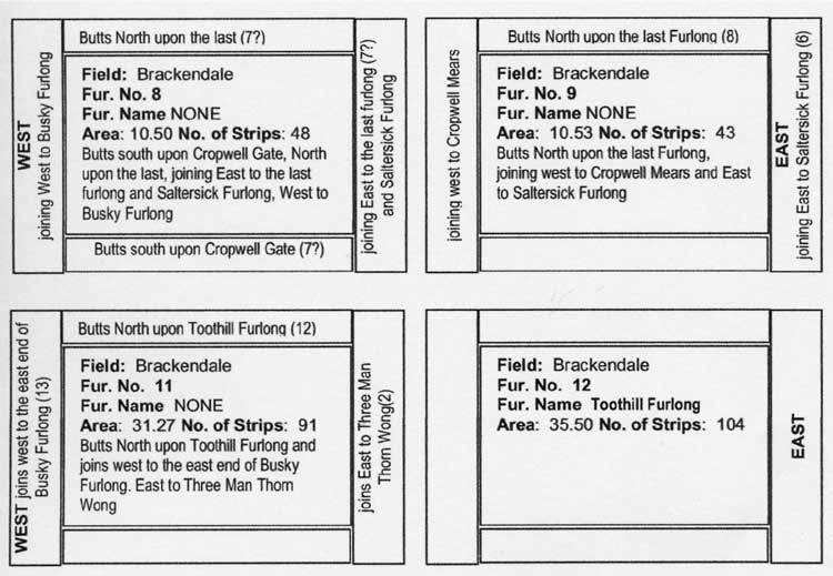
Figure 4: Sample furlong cards
A relationship was never repeated for the adjacent furlong, and one or more cardinal point was always omitted. Frequently no adjoining information was given in one or two or indeed all directions and it was unusual to be able to link more than three or four furlongs in a chain. We did not manage to establish what if any significance there was in the surveyor’s choice of term in any particular circumstance. The surveyor used the terms “butteth” or “joineth” to describe the relationship between a furlong and those adjoining it. The Orwins provide a possible clue on page 99:
“… The lands of one furlong abut direct on to those of another, or they finish at right angles to the outside land on to those of the next furlong, without the intervention of any common balk or headland”
But this does not cover every eventuality. Butting implies continuity of direction, joineth might imply joining at right angles, the missing definition is where there are two furlongs with holdings running side by side - is this butting or joining? A case can be made for both!
We are not sure of the significance of the furlong numbers. Do they indicate a possible order of survey, and therefore the layout needs in some way to be sequential? The layouts that we achieved have chains of sequentially numbered furlongs, and then the chain is broken. Might this indicate a day’s work for the surveyor and that he did not necessarily start the next day where he left off? Or might it relate to a pre-existing numbering system? - Lay out the cards to reflect the joining information as much as possible to produce a likely spatial disposition, jig-saw-puzzle style. Additional information helped, such as if a furlong referred to a known (or assumed) road (gate) or some other feature (e.g. “abuts north upon the town”, “buts south onto Cropwell Gate”).
- Produce strips of paper of a standard width (=220 yards) to represent each furlong scaled to its estimated area. Using the layout produced at 3, place the strips on a paper map in the approximate positions relative to map features and the surveyor’s direction of walking. Where necessary a long strip might be cut in two to produce a ‘squarer’ shape.
- Using the layout in 4 as a guide, produce a polygon for each furlong on the GIS of approximately the expected area following available boundaries using the hierarchy of choices described in part 2. In an attempt to make the areas as ‘accurate’ as possible, we then manipulated the furlong boundaries with respect to map features but not slavishly so. Usually we managed accuracy better than ± 10% but occasionally worse!
- Test the draft layout against the map of ridge and furrow. Trent and Peak Archaeology suggests these may be 14th century or earlier in origin, but they must nevertheless be a consideration.
- Test the draft layout of furlongs against the map of hedgerows suggested by a previous BHTA survey to be dateable to Tudor or pre 1776 enclosure times. Whilst enclosure boundaries would not necessarily closely follow furlong boundaries, there might be a correspondence where the lines are reasonably adjacent, particularly where there are identifiable sinuous boundaries that could have followed the “S” shape of strips often noted in the literature.
- Test the resulting shapes of furlongs and widths of holdings against the 1614 map of East Bridgford for any signs of congruence.
- With experience it became possible to use the GIS to rearrange furlong polygons when editing to ‘improve’ the layout.
Click here for map of the Open Fields
The maps appear as a pdf. You will need Adobe reader to view them. The size of the map can be adjusted using tools available in your pdf viewer - the image can be magnified and the hand tool used to scroll around the enlarged map.
The resulting conjectural map of the open fields of Bingham is at figure 5. Surprisingly perhaps a number of holdings were meadow or pasture rather than arable. Table 1 gives the proportions.
Table 1 Land use in open fields
Arable % |
Meadow % |
Pasture % |
|
| East | 78 |
9 |
12 |
| North | 94 |
6 |
0 |
| South | 99 |
0 |
1 |
| West | 98 |
1 |
1 |
Whilst most of our reconstructed furlongs obey the norm mentioned by other authors (eg Orwin and Orwin) of being long and narrow, some do not. Our plea is that there are similarly ‘misshapen’ furlongs at East Bridgford, 2 miles to the north of Bingham, that could be taken as a model in these and other circumstances.
The rationale for various furlongs and holdings maps is explained in other sections: