
![]()
1776 MAPS - ARCHIVE
Georgian Bingham and the Estate Terrier of 1776 (3)
Field Boundary Maps
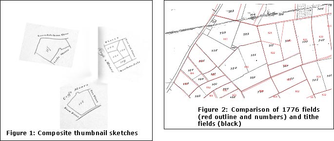
The majority of thumbnail field plans in the survey were recognisable from the tithe map of 1841. As the survey list was grouped by occupier, thumbnails for several occupiers had to be pieced together to construct an area of adjacent fields. Some were more of a challenge than others. The thumbnails usually gave the name of adjacent plots and the text information for the owner named the field in question which made finding adjacencies fairly straightforward, except that often several contiguous fields carried the same name: in this case field numbers usually helped. Distinctive shapes usually fitted tithe boundaries. The examples below, figures 1 and 2, demonstrate instances where tithe boundaries showed further enclosure activity over the ensuing 70 years to reduce field sizes, presumably to permit more intensive grazing.
Figure 1 is a composite of three thumbnail plans. 1776 fields (the red numbers on figure 2) 117 and 118 were named Crossmears in the text, the western boundary name used for fields 119-122, which were themselves named Far Plot, the eastern boundary name on the thumbnails for 117 and 118. Thus they could easily be identified as adjacent. The page of plans for each occupier (there were three) placed the fields to the west of the parish. The distinctive shape of the common boundary, possibly the preserved boundary of Buske Furlong in 1586, of 117 and 118 was preserved on the tithe map and gave the final fix. The tithe map shows that several changes occurred over the 70 year period. In 117 John Horsepool’s farm house (Fosse Farm) had been developed on the western boundary, a small garden piece appeared and the rest became three smaller fields. Field 118 was similarly divided into three. 1776 fields 119-122 became three slightly larger fields with more regular boundaries.
Although one or two boundaries changed position, there were no examples of a tithe field being a complete amalgamation of more than one 1776 field.
Note that boundaries are not quite coincident because it is not possible in the GIS program to warp the differently based and sourced maps exactly to match each other.
Occupiers of fields
The pattern of field boundaries in 1776 was the product of the process of enclosure which we think was completed in the 1690s, with some further subdivision of moors and some closes coming later particularly to improve the efficiency of grazing regimes. No records survive, but as the Stanhopes owned around 80% of the land and most of the rest was owned by the Porter/Sherbrooke family it would probably have been organised as a private enclosure agreement between the freeholders. Domain land was distributed amongst tenants as the Stanhopes no longer had it farmed on their own account. The principles of the open field system of sharing good and bad land seemed to survive as most individuals’ holdings were scattered around the parish.
68 villagers rented a total of 2446 acres in the fields surrounding Bingham; most of these also had a homestead of a few acres within the village. Figure 3 summarises these individual holdings in descending order of total acreage. Map 1 shows how in only four holdings were all the fields contiguous. These were the beginnings of the three modern day farms – Holme, Brocker and Starnhill. In each case a house existed in 1776. John Timms jnr had almost managed to concentrate his holdings, having only three small closes a little way from his main group of fields. Thus the first steps had been taken in a process of dispersal of farmhouses from the village to the countryside that took until the 1950s to complete.
Figure 3: Individual holdings
|
|
Other holdings tended to be dispersed, partly to share pasture land to the north and arable to the south, but also perhaps continuing the open field arrangement of equable distribution of land quality.
Map 2 shows the distribution of fields for the other large farmers holding over 100 acres. The amount of travelling that must have been involved is immediately apparent!
Map 3 shows those with between 20 and 100 acres. Many of these small holdings were on the parish boundary and must have involved much travelling. The two Glebe closes presumably made up for the open field glebe strips; of 1586. They were also conveniently adjacent to the rectory! Whilst William Horspool’s 21 acres were conveniently two adjacent closes, Thomas Eden’s 21 acres were in five closes at four different locations ranging from the northern parish boundary at Margidunum to the southern boundary near Wyverton. Most other farmers’ holdings were similarly scattered. Horspool was listed as a butcher in the 1795 trade directory, so would have used his land for grazing stock.
Map 4 shows the very small holdings in the fields under 20 acres. In most cases, where a holding was of more than one close these were contiguous (eg Richard Keyworth or John Hopwell). Exceptions were Elizabeth Skinner (3 separate closes), George Widnall (2) and John Bradshaw (three closes in two locations).
None of the land holders listed on map 5 lived in Bingham town, or at least were not listed as directly renting a house from the estate. It is possible they were tenants of other freeholders, but a number of the occupiers of series of small holdings in Brackendale along the SW parish boundary with Cropwell Butler almost certainly lived in that village. In 1841 several holders of land in this area can be shown through the census to have lived in that village; some of the surnames are common to both the 1776 and the 1841 groups. Rev Kirkby may have been the curate for Bingham and thus not listed with his own homestead in the town.
In 1841 a John Bower held the land shown on the eastern boundary under that name – he lived in Whatton parish. This edge of parish holdings may have been relics of some earlier land distribution arrangements or simply an indication that there were not enough potential tenants in Bingham.
Comparison of holdings sizes with 1586
Figure 4 below suggests how the middle order holdings got squeezed with enclosure etc. The proportion of large (over 100 acres) nearly doubled whilst the proportion of middle sized holdings (25 – 100 acres) dropped from 43% to under 15%. The proportion of small holders increased dramatically from 14% to 36%. Thus land ‘ownership’ was becoming concentrated in fewer hands, possibly with social consequences we have no record of.
Figure 4 comparison of holdings 1586 - 1776
1586 |
1586% |
1776 |
1776% |
|
| 100+ acres |
3 |
5.4% |
10 |
9.2% |
| 50 - 99 |
15 |
26.8% |
5 |
4.6% |
| 25 - 49 |
9 |
16.1% |
11 |
10.1% |
| 1 to 24 |
8 |
14.3% |
40 |
36.7% |
| under 1 |
21 |
37.5% |
43 |
39.4% |
56 |
100% |
109 |
100% |
Land Ownership
Freeholds totalled 290 acres. They were:
| Tenant Forename |
Tenant Surname | Sum of total acres |
| Glebe |
38.21 |
|
| H. Esq. |
Sherbrook | 96.33 |
| James |
Horsepool | 0.02 |
| John |
Bass | 1.47 |
| John |
Chettle | 8.16 |
| Mr. |
Bradshaw | 4.25 |
| Mr. |
Hains | 0.58 |
| Mrs. |
Chettle | 5.94 |
| Mrs. |
Hutchinson | 0.77 |
| Mrs. |
Needham | 1.84 |
| Robert |
Grant | 0.47 |
| Sundry |
Freeholds | 129.675 |
| The Revd Mr. |
Kirkby | 1.46 |
| Widow |
Hart | 0.006 |
| William | Bird | 0.97 |
The Earl of Chesterfield owned the rest – 2646 acres – (90%). The proportion owned by the estate had increased from the 1586 figure of 85%
Land Use
Unlike the tithe map, land use (arable or grass) is not specified in the text, but to some extent the names of fields might be taken as indicating the minimum amount of grassland – signified by the terms moor or meadow. Pasture does not appear in any names. Closes are more difficult to assess; they might be pasture or arable. Field appears frequently and might signify arable. Other terms are even more difficult to define – e.g. Cunnery Nook, Cross Mears, Brackendale and Starnhill. An initial if patchy interpretation is depicted on map 6.
The results of field walking may be helpful in further refining the assessment of land use. Four categories of finds are considered to be good markers for 18th century deposition and are shown on map 7. The high density of finds in the north central area is attributed to the existence of a village dump which has been spread by later ploughing. Other than this, the assumption might be made that a farmer would be unlikely to manure with potentially harmful material fields on which he was grazing stock on routinely. Thus one might interpret areas of high deposition as likely to have been arable. There are significant areas of virtually nil deposition on land we have annotated as debateable. In particular North and south Brackendale, and much of Starnhill. On the other hand, two areas named as meadows show high concentrations! Mid Brocker (East Meadow) may be explained by our theory that this area was enclosed relatively early and used possibly used for arable. The area by Fosse Road was Chapel Meadow. The nomenclature meadow persisted well into the 19th century when some was pasture. The picture is thus hazy and needs comparison with the 1841 situation.