
![]()
PRODUCING A MAP OF BINGHAM FOR 1586(3)
Reconstructing the Town centre
Lands of the Queen
Notes on individual houses in 1586 and their relationship to the 1776 map
Chappell Gate (Newgate Street) and West Moor Lane
(Old) Market Place
Church Gate (Street)
East Street (Church Lane and Goodwyn Lane)
Husband Street, east section (Long Acre East)
Husband Street (central) (Long Acre)
Husband Street (west) (Long Acre)
The Survey
The information for this part of the project is from Part 1 of the survey: Land holdings listed by tenants
Use of data base and spreadsheet techniques enabled accurate areas to be calculated from the a-r-d-p notation for each holding and stored as acres. Cards were produced as in figure 2, much as the WEA class had partially managed to do, and matched manually to arrive at a relative disposition of holdings.
Some sequences of cards contained within them sufficient information to choose start points on the tithe map for a sequenced chain to be developed. For instance holding number 35 had Fair Close to its west, the position of which is well known; thus a chain of 44, 9, 55 etc could be developed from the boundary information.
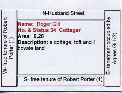
Figure 2: Sample homestead card
Click here for map of whole village
The maps appear as a pdf. You will need Adobe reader to view them. The size of the map can be adjusted using tools available in your pdf viewer - the image can be magnified and the hand tool used to scroll around the enlarged map.
The reconstructed 1776 map shows buildings; these were used as the basis for identifying the location of 1586 buildings. Houses are generally shown on our map in their 1776 shape, orientation and position. The 1776 positions are not always reflected in the 1841 dispositions, leading one to suppose a degree of new building rather than just extensions went on in the 70 year interval. Similarly, re-building or extensions might have happened between 1586 and 1776, but we have no way of telling. We can however be reasonably certain of how many extra buildings there were in 1776 compared with 1586, with the exception that the 1776 survey did not map freeholds, so most freehold dwellings were probably not shown. Where a 1586 dwelling is shown on our map we would assume it or its successor would be extant in 1776, particularly if a building is shown in 1841. If a non-freehold building is not shown in 1776 one might assume it had been demolished and not replaced.
Lands of the Queen
During the Reformation Henry VIII had closed down and confiscated the property of all monasteries and also smaller medieval manorial chapels and chantries. Such institutions had frequently been founded by landed families for their own private use and endowed with priests employed to say prayers for the souls of the founder and his family. They could either be free standing buildings or small chapels (‘chantries’) built in corners of parish churches. Bingham had examples of both types.
A private manorial chapel dedicated to St Helen had been founded in 1301-7 by the then lord of the manor at the north east corner of Chapel Lane and the modern School Lane. Its site is described in the Survey as demesne land called Chappell Close ‘in which remains the ancient walls of the chapel formerly dedicated to St Helen’. The building had obviously been left to decay since its closure in c. 1550.
The chapel had been endowed with property which included three cottages in Bingham. They appear in the survey only in the boundary information for adjacent closes. In three cases a cottage is mentioned, in others the reference is to ‘land of the queen’ reflecting the seizure by the Crown of these properties.
A chantry chapel had also been established in the parish church in 1400 known as the ‘Guild of Our Lady’, which would have served a religious society made up of many local inhabitants. It had its own chaplain to pray for the members’ souls and to celebrate saints’ days with feasts and processions. It was obviously a major local institution as it had its own separate Guildhall; the Survey records that ‘William Gervys alias Brunce’ owned the land ‘where the guildhall stands’. (See houses 13 and 14 below). He may have been one of the well-to-do Brunts family of East Bridgford, and presumably had purchased the guildhall on its sale by the Crown after its closure. This was probably a timber-framed building standing in the Market Place with a ground-floor hall for meetings and a chamber for the accommodation of the priest. The chantry was well endowed as it had owned some twelve houses in Bingham in 1546-48; by 1586 these had probably been sold to the Stapletons.
Notes on individual houses in 1586 and their relationship to the 1776 map
We have identified the site of 77 dwellings, a ruined manor house and a windmill.
This list should be read in conjunction with the conjectural map of the town centre 1586 – Map 1. The information is arranged as follows:
The first number refers to the numbers on the map;
The second [in square parentheses] is an arbitrary ID assigned by the data base and included here merely to preserve the connection to the data base ([0] indicates the property is not directly listed in the survey);
The name of the occupier (or owner);
The phrase in italics is the description given in the survey.
Additional notes by us sometimes follow. Barns and other buildings are mentioned in the survey text; these are shown but not numbered on the map.
Some notes on the relationship with 1776 information are then given including the 1776 reference number (in round parentheses) if applicable.
The list is in a loosely geographic order which hopefully will facilitate comparison with the map. A similar order is used in the section on the 1776 survey to help relate 1586 and 1776 maps.
The surveyor used four terms to describe a domestic building:
- Messuage, which seems generally to indicate a substantial home, always tenanted or freehold and can be interpreted as a farmhouse.
- Cottage, taken to indicate a smaller residence, often a single room with one fireplace.
- House, used only twice and as a second building on the site. We have tentatively identified these as the fore-runners of two known public houses.
- Tenement, some times written as ‘or cottage’ or ‘messuage or t…’. Common usage at the time did not always imply a building but merely that it was a land holding. Here we assume it would indicate building (vide seq no [29] which refers to ‘two tenements, one of which is a newly built cottage…’).
Chappell Gate (Newgate Street) and West Moor Lane
The maps appear as a pdf. You will need Adobe reader to view them. The size of the map can be adjusted using tools available in your pdf viewer - the image can be magnified and the hand tool used to scroll around the enlarged map.
1 [50] John Gabriell. A small cottage. In 1776 it was still a small parcel of land with a cottage - occupied by Elizabeth Wilson (374)
2 [28] Edmund Bludworth. A tenement and 5 bovates of land with yard, barns and 3 crofts. In 1776 John Brooks’ house (377).
3 [29] John Ludlam. Two tenements and 8 bovates of land one of which is a newly built cottage (therefore without common) with a croft, one newly built. Two buildings are shown in 1776 - John Timm jnr
4 [52] William Walker. Cottage. A house is shown in 1776 occupied by William Selby (358).
5 [4] John Wilson, Freehold. A messuage and two bovates of land, now in the tenure of John Ludlam. 1776 shows as sundry freeholds with no map so we do not know if there was a house there in 1776. The likelihood is that there would have been (358).
6 [38.1] John Allane. A mill on the west side of West Moor Lane and 1 bovate of land
7 [55] John Richardson. Cottage with toft. In 1776 Mary Parr’s homestead (she had two, the other on Long Acre) (363)
8 [9] William Kirke. Freehold. A messuage and two and a half bovates of land and meadow. Jesper Doncaster (362) in 1776 but not freehold.
9 [44] Thomas Johnson. Cottage toft and small orchard. In 1776 this was a close occupied by Jonathon Bass but no house is shown – his was at the corner of Church Street/Cherry Street.
10 [35] William Beane. A cottage with croft and 1 bovate land. 1776 George White (367), house, probably (part of?) the present Close Acre.
(Old) Market Place
The maps appear as a pdf. You will need Adobe reader to view them. The size of the map can be adjusted using tools available in your pdf viewer - the image can be magnified and the hand tool used to scroll around the enlarged map.
11 [60] Thomas Leake, demesne land, the site of the manor which is now in an exceedingly waste state and ruinous except for two barns and one dovecote
12 [58] Thomas Gill jnr, a cottage lately constructed in the Market Place. Possibly the site of George Baxter’s cottage in 1776 (350). If so this would have been a forerunner of the Kings Arms (Crown) Inn.
13,14 [7] Freehold of William Gervys, alias Brunce, 2 cottages and a parcel of land where the guild hall stands + 5 strips of arable. He had three holdings (in the name of Brunce) in the open fields – were these five additional and adjacent? This could have been the site of the (modern, so called) Manor House (347), which is why we have placed them here; there is no border information for any of the adjacent properties.
15 [38] John Allane, who also had the Mill at 6. A cottage, (346)
16 [56] The descriptions for this and 17 taken together are confusing. [56] clearly states ‘a cottage called the common bakehouse on the east side of the old market and next to the site of the rectory’ occupied by John Fisher. Cottage no. 17 is said to have on its west boundary a Cottage occupied by John Fisher (18 on the map), on its north side Church Gate Lane, on its east a toft occupied by Richard Radcliff (33 [45]) and on its south side a Croft occupied by Thomas Dyrrie. The directions for the latter place it in Cherry Street and not here. Most of the descriptions in this general area are lacking information for some boundaries so a fair amount of conjecture is required. It is possible his croft was separate from his cottage but this cannot be demonstrated from the text. The relationship with Fisher’s cottage firmly places that on the south side of Church Gate/Market Place not the north side. It would still be ‘near’ the rectory. We have resolved the problem by placing a separate bake house on the north corner of Church Gate and the Market Place. It is also possible the surveyor or clerk made some mistakes.
17 [23] Elizabeth Allayne. A tenement or cottage with small yard and cottage and 3 bovates of land. Why two cottages? In 1776 it was Daniel Parley’s house and garden (293). Only one building is shown on that plan.
18 [56] John Fisher (see 16 above)
19 [10] John Northe. Freehold. A cottage and toft. Placed here to fill the space after all other locations allocated. By 1776 it had passed to the Chesterfield estate and was occupied by Richard Skinner as a homestead etc (289); he held a second homestead bordering this one and fronting Long Acre.
20 [8] Edward and Nicholas Spybie. Freehold. Together [they] hold 1 messuage and 2 bovates of land with meadow. (Were they father and son or brothers?) Placed here because it was freehold in 1796 (289; no owners or map given) in 1776. In 1841 it was a set of tenements owned by James White and rented to several tenants. It is now the Co-op! There is also an 18th century farmhouse within the parcel of land.
21 [49] Robert Parthorpe. A cottage with garden and appurtenances. In1776 it was Thomas Eden’s house (365).
22 [0] Not separately recorded in the survey, but a cottage in the Market Place - a cottage belonging to the queen - was given as to the south of 21. By 1776 the cottage had presumably been acquired by the Chesterfield estate and was home to John Wrath (282).
Market Street
No holdings had Market Street as a boundary.
Church Gate (Street)
The maps appear as a pdf. You will need Adobe reader to view them. The size of the map can be adjusted using tools available in your pdf viewer - the image can be magnified and the hand tool used to scroll around the enlarged map.
23 [0] The rectory, which is not mentioned directly in the survey documents except as part of the location information for the common bake house, 16) and house 24.
24 [42] Brian Richmond, a cottage and croft and small orchard. The location for this cottage is confirmed in the deeds for 7 Church Street, which was in the ownership of (a later) Brian Richmond in 1683. In 1776 it was occupied by William Spencer (342
25,26 [3] John Ludlam, 2 cottages, half bovate of land and a toft in Bingham. Ludlam also held the tenancy of cottages at numbers 3 (Chapell Lane) and 5 (West Moor Lane). The deeds for 19 Church Street confirm that this proprty, with two cottages, was under one ownership but they go back only to 1705 so Ludlam is not mentioned. See (340) and (341) in 1776.
27,27a [0 ] This is mentioned only as being on the southern boundary of holding 41 - two cottages belonging to the Queen, one of which has common of pasture, they are bounded on the south by the cemetery. House 33 seems in most respects to fit the (original) land parcel of 21 Church Street. A painting from 1855 and hanging in the church shows a pair of semi-detached thatched cottages here and a detached cottage in what is now the side garden.
28 [47] Thomas Bartrum (Barton in the list of jurors at the front of the survey). A cottage. No strips. In 1776 it was William Brooks’ house and garden (305),
29 [48] Thomas Childron. A cottage and garden. No strips. In 1776 it was John Bass’ house (298) and garden (he was a plumber and glazier). The location information includes on the east ‘In the angle between Kirk Gate and Selby Lane’, which is the only reference to Cherry Street having been Selby Lane, continuing across Long Acre from the modern Jebb’s Lane.
30 [37] Isabella Smyth. A cottage with garden and small toft in Church Gate, also widow, several strips [unspecified] attached to cottage. She had a single holding – in Furlong 11 West Field where she was listed as Widow Smith. In 1776 it was Richard Brown’s house and garden (297). Isabella’s homestead is said to have the cottage of John Wyverton to the west, but John Worthington’s details do not mention him, having Isabella on his east.
31 [ ] John Wyverton (see 30 above).
32 [51] John Worthington. 1776 Ann Gissop, house and garden (295). Strangely this cottage has Old Market Place to the north although its neighbours on both sides have Church Gate! Old Market Place is north of 18, further west, so this must be a mistake not an indication of an older Market Place.
33 [45] Richard Radcliff. A cottage and toft. In 1776 it was John Pilgrim’s House (294) etc. This is on the site of part of and was possibly the forerunner of the Chesterfield Arms.
Church Lane and Goodwyn Lane (East Street)
The maps appear as a pdf. You will need Adobe reader to view them. The size of the map can be adjusted using tools available in your pdf viewer - the image can be magnified and the hand tool used to scroll around the enlarged map.
34,35,36 [ ] The entry for homestead 41 has a memo that John Ludlam has three cottages there which are newly built, of which one has common of pasture. It is known that the present old cottage, No 1 Church Path, used to be a terrace of three, preserving the plan if not the buildings through from 1586 to the present day! John Ludlam owned what is now 19 Church Street.
37 [41] John Ireland, a cottage and croft divided into two, which had disappeared by 1776.
38 [43] Thomas Banister, a cottage and croft, held by John Wrath in 1776 (337). Described as having Kirk Lane to the west and the cemetery to the south.
39 [46] Percevell Leaze., tenement or cottage with croft. (see 53). In 1776 this was also occupied by William Brooks (309).
40 [30] Geoffrey Jennyngs. A tenement and 5 bovates of land, yard, barn and croft. In 1776 it was Thomas Chettle’s homestead (330). The 1776 plan shows two buildings, one of which we have used as a position for the 1586 barn.
41 [31] Brian Goodwin., A tenement and 5 bovates land, with barn and two crofts. In 1776 it was James Johnson’s homestead and Home Close (329).
42 [32] William Morley. Tenement and 4 bovates land, barn yard and 2 crofts. In 1776 it was Joseph Askew’s, homestead etc (316).
43 [18] John Wright., A messuage and 4 bovates of land with barn, yard and croft. In 1776 it was Daniel Stafford’s homestead and close (315), the running of which he combined with teaching! It was on the site of the present 8-10 East Street.
Husband Street, east section (Long Acre East)
The maps appear as a pdf. You will need Adobe reader to view them. The size of the map can be adjusted using tools available in your pdf viewer - the image can be magnified and the hand tool used to scroll around the enlarged map.
44 [19] William Spybie. A messuage, 6 bovates of land, a yard, a barn and croft with other buildings. In 1776 it was tenanted by Richard Little and was known as “Simpson’s House and Close” (314), but no building was shown – Little’s homestead was elsewhere. Simpson is at 48 below.
45 [0] This is noted as Land of the Queen bounding to the east and west of the closes shown. There is no mention of a cottage; we have shown as a cottage, influenced by Donkey Green’s Cottage which is where we have it. But DGC may well date from just after this! The house history by TPA says: Three internal timbers were sampled for dendrochronology but only one could be dated, to somewhere in the 1570s or 1580s. The timber in question is a vertical support for the cross-beam still attached to it. Whilst it not inconceivable that the cottage dates from then, proof cannot be carried on one sample alone; the timber may conceivably have been reused from another building. So if there was a cottage in 1586 it would have been a recent build! Maybe the estate bought the ‘land of the queen’ and built DGC.
46 [1.1] Robert Porter. Freehold. A messuage and 5 bovates of land and 5 bovates of meadow, where he lives. {And also an extra note - But Geoffrey Jennyngs, one of the jury men, vaguely remembers that Thomas Porter, grandfather of Robert Porter, was in the tutelage of Sir Brian Stapleton and showed Geoffrey the place where he used to sit at the table in the hall called Burton Hall. Alone as appointed by Brian}. Thus there was some connection between Porters and Stapletons. The location of the large parcel of land is determined by boundary notes for other properties. The position shown for the house, east of East Moor Lane, is determined by the results of BHTA’s geophysical survey of Crow Close; see chapter ** for the detailed evidence.
47 [17] John Skynner. A messuage and 3 bovates of land with barn, croft and yard, lately bought from John Blythe. This is the only cottage not in the main part of the town – it is not shown on the conjectural town map. In 1776 George Widnall held it as a part of East Meadow but there was no building.
48 [16] Robert Simpson. A messuage, 5 bovates of land, yard, garden, barn and other buildings and also a croft. In 1776 it was part of the Porter/Sherbrooke Freehold.
49 [2] George Gelstrop. Freehold. A messuage and 2 bovates of land lately belonging to William Arwy. In 1776 it was William Green’s homestead and close (241) but not freehold.
50 [12] George Gelstrop. Freehold. A messuage, a toft, two cottages and 3 bovates of arable. In 1776 it was Widow Oliver’s homestead (242) but not shown as freehold.
Husband Street (central) (Long Acre)
The maps appear as a pdf. You will need Adobe reader to view them. The size of the map can be adjusted using tools available in your pdf viewer - the image can be magnified and the hand tool used to scroll around the enlarged map.
51 [40] John Stout. A cottage and croft. In 1776 it was Thomas Wright’s homestead (313).
52 [20] Richard White. A tenement and 6 bovates land, a barn and croft. In 1776 it was John Chettle’s homestead (311), now Porchester Farm House.
53 [0] Land belonging to the Queen; A cottage occupied by Percivall Leaz. Percevell Leaze occupied cottage 39, which had on its south ‘lands of the queen’. The entry probably means that 52 had two westerly neighbours, which our map shows it has. 53 would not have been a cottage at all, since other references to lands of the queen have mentioned a cottage if one was there. In 1776 it was occupied by William Green (310), who also had a cottage on the south side of Long Acre East.
54 [21] Nicholas Selby. A messuage and 4 bovates of land with barn, yard and croft. In 1776 it was one (308) of William Petty’s two homesteads, each with a house.
55 [22] Thomas Dyrrie. A messuage and 4 bovates of land with barns, yard and croft. In 1776 it was George Widnal’s house and garden (303), forerunner of Dane Cottage.
56 [57] Elizabeth Allen. A cottage. The border information is that Brian Wheatley’s property (24) is to the west. However the information for no. 24 is that to the east is a cottage in occupation of Thomas Pare! It is probably a case of there being two neighbours, which is as we have shown it. No. 56 is next to Selby Cross, which we assume to marked the cross roads of Husband Street (Long Acre) and Selby Lane (Jebbs Lane/Cherry Street). Thus it is a forerunner of Regency House which now stands on that corner. In 1776 it was occupied by Samuel Baxter (299).
57 [0] Thomas Pare, This is not listed as a separate holding. See 56 and 58, which describe this is a Cottage in occupation of Thomas Pare. We base our location on the 1776 map which shows two buildings occupied by Samuel White. The site is now occupied by 61/63 Long Acre. Trent and Peak Archaeology surveyed this for us some years ago (see web site) and concluded it had been a three bay farmhouse dating from about 1617, so it could be the replacement farmhouse building for 57.
58 [24] Brian Wheatley. A Messuage and six bovates of land with yard, barn and croft; to the east was the Cottage in occupation of Thomas Pare. No. 24 would have been the second building in Samuel White’s homestead (296) in 1776.
59 [25] Thomas Skynner. A Tenement with 4 bovates of land, barn, yard, and croft. It was Thomas Richmond’s house and garden (292) in 1776.
60 [26] Thomas Spybie jnr. A messuage and 5 bovates of land, yard, barn and croft. In 1776 it was the homestead of Richard Skinner (291), possibly a descendant of Thomas Skynner of no. 59 in 1586. It is possible this was Skinner’s plot, but the plans for 1776 are shown in chapter ** to be correct; it may be a mistake by the 1586 surveyor but other plots are consistent so it seems more likely the family simply moved, perhaps on the expiry of a three life lease.
61 [27] Robert Dyrrie. A messuage and 2 bovates of land, barn and croft. In 1776 it was William Granger’s house and garden (286).
72 [68] William Smith. A tenement and 2 bovates of land, barn and yard. In 1776 it was one of Samuel Wright’s two homesteads (264); the other was not built upon in 1776 but had been (no. 68 above).
73 [1] Robert Porter was the freeholder, the occupant John Serteine. A messuage and 3 bovates of land and 3 of meadow lately in the possession of John Serteine. In 1776 it was in the freehold of H Sherbrooke (263) but only the close is shown not the house. It was the forerunner of Tealby House
74 [34] Roger Gill. A cottage, toft and 1 bovate land. In 1776 it was William Doncaster’s house and homestead (262).
75 [13] Agnes Musson. A messuage, five bovates of land, barns, stables and other buildings, yard, garden and croft lying together. 1776 Widow Foster’s homestead was in same location (261). It was the forerunner to Banks House. By 1841 the homestead and outbuildings had achieved its present location and size at the south of the plot. Even in 1586 it was a significant property with one of only two stables in Bingham.
76 [14] Richard Maplethorpe. A messuage and 4 bovates of land, barn, yard and croft. In 1776 it was John Timm snr’s homestead (259).
77 [6] Thomas Selby, freehold, A cottage with house and toft. A bovate of land and meadow. This is only the second of two 1586 properties with a cottage and a house - might this indicate a public house? In 1776, Mrs Hutchinson had the freehold homestead (259). Mrs Hutchinson is in the trade directory for 1793 but with no occupation. William Hutchinson, aged 65 of independent means and related to the farming family of Starnhill, occupied it in 1841. However, in 1841 The Marquis of Granby (first mentioned in 1822 as base for a carrier) was next door at 1586 no. 76 and was not freehold! In 1841 John Tinkler was tenant of both a house (plot 288) and a homestead (289). Was the house the inn? Does this indicate no. 6 was not an ale house in 1586. The detail for plot [15] certainly places [6] on its west. Did the business moved next door between 1586 and 1822?
78 [15] Robert Selby. A tenement with 6 bovates of land, a barn, yard and croft. In 1776 it was John Johnson’s homestead (257).
79 [39] Thomas Gill. A cottage and garden. It seems not to have survived until 1776 but became part of James Horsepool’s homestead, see 80 below.
80 [54] John Carlton. A cottage and toft. This and 79 seem to have been subsumed into the farmstead of James Horsepool by 1776 (255). 79 and 80 are the site of the modern Bowls Club, which has converted a very old barn/dovecote into their club house. During construction of the green a large quantity of pink/red bodied earthenware and other shards were recovered, strongly indicative of a farm midden or rubbish dump.
Husband Street (west) (Long Acre)
The maps appear as a pdf. You will need Adobe reader to view them. The size of the map can be adjusted using tools available in your pdf viewer - the image can be magnified and the hand tool used to scroll around the enlarged map.
62 [36] Henry Harison. A cottage in Husband Street next to Per Cross; mention here and in 11 fixes the position of the Per Cross. In 1776 it was Thomas Brown’s house and garden (285). Today the plot houses part of the large Chinese restaurant.
63 [11] Thomas Johnson, described as "calcionarius” - a spurrier or shoemaker. Freehold. It is the old post office house (39 Long Acre), part of the present building being one of the oldest houses in Bingham (probably timber framed). The survey says it is a cottage and toft next to "per cross" in Husband street. The present house being in a corner by the cross and towards the market. By 1776 it had passed to the Needham family.
64 [53] Thomas Atkinson. A cottage next to the tenement occupied by Thomas Redman with its toft. This is 21 Long Acre, one of the oldest houses in Bingham, possibly dating from the 16th century but modified by 1670s and later. The TPA study found: “there may be indications of a late medieval design and an earlier timber phase, which was subsequently altered. However, the present form of the building suggests a likely date after 1600.” We have shown it in its current position which corresponds with the 1776 map, when it was the house and garden of William Petty (276).
65 [64] Thomas Redman. A messuage and 5 bovates of land with yard, barn and stable. Also garden and croft together. Is shown in its 1776 position, but the tithe map shows a building immediately east of this instead, which of course could be a rebuild. This is the site of the present row of Victorian Villas (1880s), and indeed is in front of the present funeral directors’ premises. 65 could be the original house and workshop of the monumental mason who preceded them. In 1586 this was one of only two premises noted as having a stable as well as barns etc. In 1586 Thomas Redman had strips totalling 43 acres. In 1776 it was George Beecroft’s homestead (275).
66 [63] William Stapleton. A messuage or tenement and * bovates land with two barns and other buildings, two closes called costes or crofts both together. It is shown in its 1776 e-w orientation. In 1586 it was in the possession of William Stapleton, the lord of the manor’s brother and bailiff, who seems to have farmed 40 acres of strips as a tenant on his own account (i.e. not including demesne holdings worked on behalf of the lord and probably managed by him). In 1776 it was the homestead and home close of William Horsepool (271).
67 [65] Thomas Spybie Snr. Messuage and 4 and a half bovates land with yard barn and garden in a street called Husband Street to the south side (i.e. to the south side of Husband Street) is shown in the open E shape of 1776, which might have been a later development or might have included the barn which we show separately. Thomas Spybie snr farmed 37 acres of open field holdings. We have located it on the site of the present Carnarvon House. In 1776 the plot (270), occupied by Samuel Parr, had a quadrant of land with a house etc (occupied by Mary Parr) in its north east corner, plot 269. This seems to have been a later development perhaps to house Samuel’s mother as a kind of dower house. There are a couple of old barn conversions here now, on ‘The Paddocks’.
68 [66] Stephen Parke. Messuage, 6 bovates of land, barn, yard garden or croft. There seems not to have been a 1776 equivalent building, when the close was described as a homestead of Samuel Wright, but his house was at the north east corner of Fisher Lane. The old house seems to have been demolished by then.
69 [33] Ralph Banister. A Cottage with barn and toft and 1 bovate land. By 1776 it had become the home and workshop (267) of the Skinner family of coopers – it is now named “The Cooper’s Cottage”.
70 [5] Alexander Rowarth. Freehold. A cottage, house and croft and a bovate of land and meadow as appears in the common pasture under the name of Alexander Rowarth's close. It was on the site of the present Wheatsheaf Inn. In 1776 it was also freehold (in the name of Mr Hains, 266), as public houses often were, and not mapped. Only two homesteads in 1586 had a second domestic building – the other was, we think, the site of the later Marquis of Granby inn (see 77 below). Perhaps these additional ‘houses’ were the forerunners of the inns.
71 [67] Richard Smith, a messuage and 4 bovates of land, a barn with garden and croft. In 1776 it was Richard Little’s homestead (265). This eventually became the site of Bingham’s first public school, set up in 1841 by Rev Robert Miles on land donated by the Earl of Chesterfield. The original building, with a locally common half-hipped pantile roof, could have been an eighteenth century barn on this homestead.
81 [59] Thomas Wragby, a windmill from ancient times situated in the South Field. No cottage is mentioned in the survey but Wragby does not appear anywhere else so must either have lived at the mill, in a cottage owned by a freeholder or outside the parish