
![]()
HISTORY OF BINGHAM
Links to this page:
Buildings at Margidunum
Trade and crafts
The Carnarvon School Roman site
ROMAN OCCUPATION
The Romans arrived into what is likely to have been a thriving, well-populated area, but the economic impact of their arrival must, nevertheless, have been considerable. By building the Fosse Way, improving other roads and building the small town of Margidunum they provided a focus for wide-ranging changes in trade, agriculture and the pattern of settlement.
On arrival in AD 50-55, the Romans chose to site their garrison within or close to an existing Iron Age settlement near the Margidunum roundabout. Although the army had moved on by about AD73 the town of Margidunum grew around the site of the garrison. In the immediately surrounding areas, villas were built at Newton, Car Colston and, possibly, East Bridgford, while in Bingham a substantial farm, if not a villa, has been found on the site of Carnarvon Primary School. Excavations on Long Acre, behind the Chesterfield Arms, revealed a Roman cemetery and ditched field boundaries that might have belonged to a farm nearby, but is now under housing. In the rest of the parish there appears to have been a change from stock rearing to arable farming. The people in long-established British settlements at Parson’s Hill, Granby Lane and Lower Brackendale adopted Roman ways of living, while new farms grew up in several other places.
Margidunum
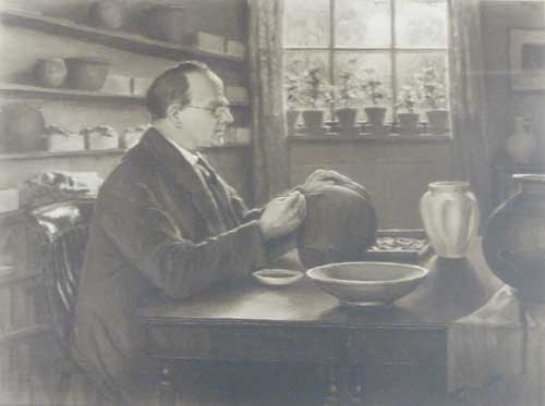
Felix Oswald put aside a room at the University where he studied and displayed the Margidunum finds. Here he is studying one of the complete pots (probably from one of the many wells he excavated). He was the first person to study Margidunum in the modern period.
Original picture in the Nottingham University Museum Photo: Robin Aldworth
The town does not appear to have had any status within the Roman administrative structure, though the high quality of some of the artefacts recovered from Margidunum during excavations by Felix Oswald was built, suggests that there was probably some sort of official living there. The town clearly fulfilled a local need because it grew into quite a substantial town, albeit in an unplanned way. At its maximum development (see Figure 3.17) there were houses along the Fosse Way for about half a mile in both directions from the centre (the present roundabout) and along the road to East Bridgford (A6097). Fairly high-density pottery scatters in the Bingham segment show that there must have been quite an extensive field system behind the houses along the road, possibly with small cottages within it.
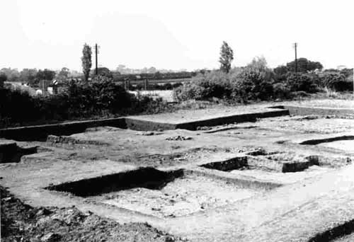
Excavations at Margidunum
Margidunum was excavated twice in the twentieth century. The first time was in the 1920s. The second time was in 1968 when the site was about to be crossed by a new road scheme and roundabout. This photograph, shows part of the excavation in 1968 (Photo: Joan Taylor).
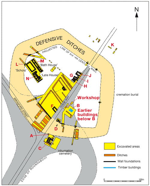
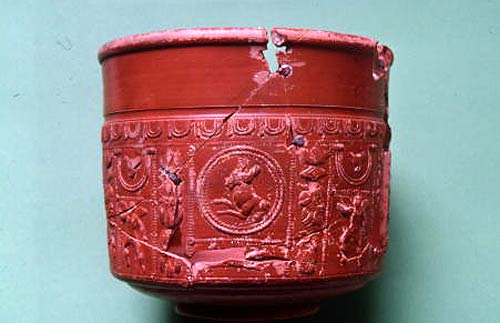
Although only partly excavated a plan (see image above) of the central part of the town has been produced and gives a good impression of the development within the fortifications. Adjacent to the Fosse Way there are ditched compounds associated with timber buildings and pits yielding iron slag. These areas could have formed part of a civilian or industrial compound associated with an adjacent fort. Early finds include samian ware bowls (see photo below) from Gaul, other fine pots and metalwork of military type - notably an iron arrowhead and pilum (spear) (see photo below) and bronze belt-plate, pendant and horse harness fitting.
Fine pottery bowl repaired with lead rivets found at Margidunum. It was imported from Gaul (Nottingham University Museum. Photo: R. J. A. Wilson).
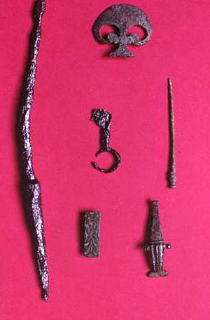
Iron spearhead (left) and bronze belt-plate, brooch (bottom), key, pin (middle) and pendant (top) found at Margidunum (Nottingham University Museum. Photo: R. J. A.
The early buildings are likely to have been of timber and thatch. Stone buildings were built after the mid-second century. Later that century an earth rampart with at least one outer ditch was constructed around the town centre. Traces have been found on the west side of the Fosse of simple rectangular buildings with beaten clay floors, stone foundations, timber superstructures and probably thatched roofs, and just outside the southern defences a three-roomed stone-footed building with adjacent yard. Several more substantial buildings may also date from this period, including perhaps both Oswald's 'schola' (a large rectangular stone-footed building) and an adjacent bathhouse with under-floor heating, concrete floors and painted wall plaster. In the third and fourth centuries the rampart was enlarged and fronted by a stone wall, new defensive ditches and an outer bank. Abundant finds of these periods were recovered by Oswald and Todd, but surprisingly few buildings may be ascribed to this late period. A notable exception is the so-called 'late house': a multi-phased stone-footed building comprising a range of four rooms joined by a corridor with projecting wings, with concrete floors, slate roofs and painted walls.
For more detail of the buildings found in Margidunum click here.
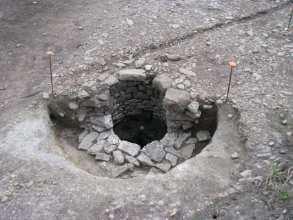
Outside the central defended area, excavations carried out in 2009 prior to building work on the new A46 revealed buildings along the A46 and the A6097. One site within the parish of Bingham about 130 metres south west of the Margidunum roundabout showed the bases of two rectangular buildings, one of which was close to a stone-lined well (see photo below). Among the rubble used to backfill the hole within which the well was constructed were several pieces of pottery that suggest that the well was constructed in the mid 2nd century. The top metre of this well has been removed and rebuilt by BHTA as a permanent feature in the Town Cemetery on The Banks.
While there is no direct evidence of an official living at Margidunum many of the finds recovered during the excavations there suggest that people of status occupied the houses within the defended town centre. These include fine glass ware, enamelled bronze boxes, (see photo below) bone combs and bronze spoons. There are also ink wells and a stylus (scribing tool) which suggest that there was an official there at one time. Such a diversity of objects has been recovered from the excavations in Margidunum that a good picture has emerged of the range of crafts that may have been practiced there and of the trade links that must have existed with other parts of the Roman Empire. For details of this click here.
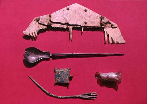
Bone comb, bronze spoon, fragment of glass flask and bronze enamelled box lid and bronze pin found at Margidunum (Nottingham University Museum. Photo: R. J. A. Wilson).
Burials have been recorded within and outside the town centre. A late inhumation cemetery comprising at least twelve graves was excavated to the south of the town; two burials were placed in lead coffins and one other was associated with fine bronzes, including brooches and bracelets. A second century cremation was found east of the town. It was accompanied by cups, bowls, plates and jars, one of which contained oyster and mussel shells.
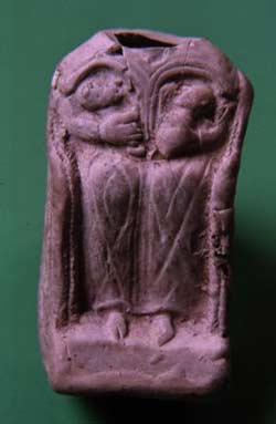
Pipe-clay figurine
Though headless, this figurine of a female sitting in a basketwork chair with two infants, is thought to have represented a mother-goddess. Such items were imported from France and served as portable statuettes or offerings to gods
(Nottingham University Museum.Photo: R. J. A. Wilson).
Evidence for religious beliefs is provided by two pipe-clay figurines (see photo above) of the mother goddess holding a pair of infants and part of a Venus pipe-clay figurine. These portable icons were imported from Gaul and were found amongst other domestic rubbish dating to AD150-250. They no doubt functioned as portable statuettes or offerings to the gods. Other finds from Margidunum, including face pots
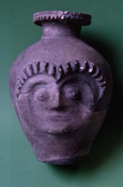
Face pot
Possibly made in Lincoln in the third or fourth centuries, this is one of three face pots found at Margidunum, each thought to have represented a deity (Nottingham University Museum. Photo: R. J. A. Wilson).
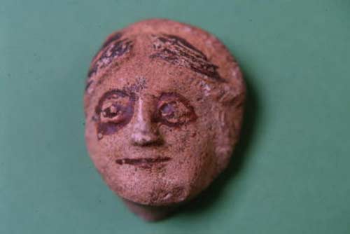
This face, possibly made at Lincoln in the third or fourth centuries, is from one of three face pots found at Margidunum. Two were formed like a Toby jug, but this face was on the neck of a flagon. It is thought to have represented a deity (Nottingham University Museum. Photo: R. J. A. Wilson).
and a relief carving of a warrior might also have a religious significance.
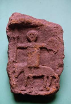
Mounted warrior
A relief carving in stone of a mounted warrior holding a round shield and spear, which is thought to be related to a warrior cult associated with the Roman god Mars (Nottingham University Museum. Photo: R. J. A. Wilson).
Carnarvon Primary School site
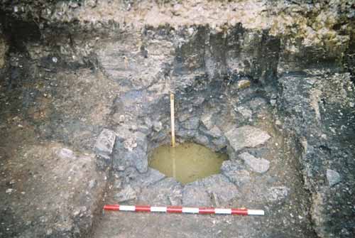
The well, found in 2002 at Carnarvon Primary School, is situated at the boundary between deposits of clay (Holocene in age) and Triassic sandstone and was probably a natural spring originally. The dark deposit above it is an organic silty, sandy clay with pebbles in it and was probably laid down by flood waters at some time after the site was abandoned.
Photo: Tony Sumpter
Evidence of a possible Roman villa on the site of Carnarvon Primary School was found when the school was being built in the late 1960s. Work on new extensions in 2003 and 2008 yielded more information about the Roman occupation of the site, including a stone-lined well. (see photo above) The finds recovered include fragments of flue tiles, which show that the house was a building of substance with a central heating system and possibly a bath house, but the information on the site as a whole is fragmentary. It is likely that this is the site of a villa, but there is no certainty about it. Full details about this site can be seen by clicking here.
The Hinterland
Away from Margidunum the wide distribution of Roman pottery sherds around the parish indicates that during the 350 years of the occupation much of the available area of what is now the parish was put to use (see Figure 3.14). There are some small areas of the lake deposit in the north of the parish that have no sherds, which may indicate that they were either marsh or bog, but most of the lake appears to have been available for agriculture. Elsewhere, barren patches may have been woodland or pasture.
The Iron Age settlements on Parson’s Hill, Granby Lane and near Lower Brackendale Farm provide evidence of continued occupation during the Roman period. On Parson’s Hill a Roman pottery scatter over crop marks indicating enclosures, ditches and possibly houses, lies to the east of the Iron Age scatter with only a little overlap and seems to indicate that the settlement was moved eastwards after the arrival of the Romans. There are two small clusters of Roman pottery near Lower Brackendale Farm in the south-west corner of the parish. One lies on crop marks that indicate two enclosures side by side and a possible hut circle in one of them. There is no Iron Age pottery here, but 500 metres to the north Iron Age and Roman pottery are present together in the same small field.
The largest clusters of Roman pottery outside Margidunum are at Granby Lane and Starnhill Farm. In the Granby Lane site (see Figure 3.12), where there is more Iron Age material than at any other except Parson’s Hill, samian ware was recovered suggesting a Romanised house here of some status, though no ceramic building material of likely Roman origin was found. There is evidence that the inhabited area shifted north-westwards during the period of Roman occupation from the 1st to 4th centuries. The largest concentration of Roman pottery outside Margidunum is the double-ditched enclosure clearly visible as crop marks near Starnhill Farm (see Figure 3.12). There is only a single Iron Age sherd here and very little 1st and 2nd century Roman pottery. While there is a possibility that there was an Iron Age farm here most of the pottery found is 3rd - 4th century, which suggests that the double-ditched enclosure may be Romano-British. Crop marks to the north east of the enclosure suggest an associated field system. Most of the sherds collected here are grey ware and there is an interesting decrease in the ratio of fine ware to domestic ware here compared with Margidunum, which reflects the rural versus urban setting.
Finding the sites of farms or settlements from pottery scatters without any other indications, such as crop marks, is difficult because there are no certain criteria for identification. However, at Dunstan’s Clump in north Nottinghamshire, where there are good crop marks defining a Roman brickwork field system, small clusters of pottery are considered to indicate the sites of middens near households. In Bingham there are six clusters that are not associated with any other evidence of possible habitation. In addition, there are three sites identified by crop marks, plus the Carnarvon Primary School site and the possible site on Long Acre behind the Chesterfield Arms Inn. There are possibly other sites under Bingham, but excluding these, the 11 sites identified as possible farms are spaced between 450 and 1500 metres apart, which is similar to the spacing between Roman farmsteads in heavily farmed areas elsewhere in the Midlands.
Between the clusters there is a thin scatter of pottery covering most of the parish. The most likely interpretation of this is that it was delivered to the fields in manure and that much of the parish was under arable cultivation, possibly growing crops commercially. It is possible that the increased labour required for arable cultivation compared with stock rearing lead to growth in the long-established British settlements and the establishment of a number of new small farms among the fields. Most of the clusters are too small for detailed analysis, but some of them include sherds from wares dated as early as mid 1st to 2nd century and sherds of 3rd-4th century are quite abundant. It is not difficult to imagine the contemporary landscape as a network of fields and small farms linked to each other and to Margidunum by lanes and tracks. There may have been some small areas of woodland and in the south. To the north of Parson’s Hill there may have been some boggy wasteland. But the over riding impression would have been of a busy and productive rural landscape.
Decline of Margidunum
There seems to be evidence to suggest the Margidunum was served by a productive, rural hinterland from early in its history at least until the 4th century. Margidunum, however, seemed to have had its heyday in the 2nd century. The town centre appears to have been flooded in the 3rd century, which may have contributed to its stagnation as a developing town because there are so few buildings in the town centre that can be attributed to the 3rd-4th centuries and only one, dated by pottery as being after the mid 4th century. In the ribbon development along the Fosse Way and the Bridgford Road, however, little is known from excavations and it is conceivable that while the town centre went into decline Margidunum continued to flourish here in the 3rd century. Certainly the pottery scatters along the Fosse Way in the Bingham section show no shortage of 3rd-4th century material.
Late 4th century pottery, (see photo below) however, is scarce and is found only at Margidunum and the double-ditched enclosure at Starnhill. However, concentrations of Anglo-Saxon pottery have been found at Margidunum, Granby Lane, the Starnhill double-ditched enclosure and near the Lower Brackendale Farm sites. This seems to suggest continuity of occupation at these long-established settlement sites at least into the 5th century and probably for longer. Several of the newer Romano-British farms that were scattered around the southern part of the parish seem to have disappeared before the end of the 4th century, which might indicate that there was an economic decline that affected Margidunum town and the hinterland farms during the last decades of Roman occupation.

Oxfordshire red colour-coated ware base sherd, late 4th century