
![]()
BINGHAM DEVELOPED AND REDEVELOPED
Progressive change
The growth of Bingham from a village of about 350 people in 1086 to a little over 1000 in 1801 has left little record in its built heritage. There is only a handful of buildings dating earlier than 1700. Most of the domestic buildings of that time would have been mud walled and thatched and demolished during later redevelopment. During the eighteenth century, however, brick buildings started to appear, including three-story farmhouses. Many eighteenth century buildings remain, including the present-day 39 Long Acre, which may have been originally thatched. The Wheatsheaf Inn, with the date 1792 on the front, may originally have been a two-storey building that had an extra floor added.
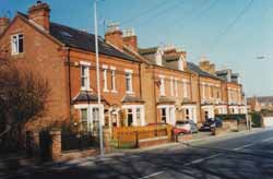 Porchester Terrace Built between 1883 and 1887, possibly by James Walker, for middle class residents of Bingham this row was originally called Porchester Villas. Several notable Bingham residents lived in them at the turn of the century. Photo: Joan Taylor |
In the first decade of the nineteenth century there
was a building boom as low-cost housing was built for what seemed to be
a growing workforce. There were big developments in Union Street and Needham
Street and elsewhere as rows of terraced houses and yards were built.
Among the few buildings left in Union Street is Butler’s
butchers, now a pizza restaurant. All the important civic building, such
as the schools, courthouse and chapels were built before 1852.
The next major period of house building came after the arrival of the
railways in 1851. Houses suitable for the middle class, such as Porchester
Terrace on Long Acre and similar detached and semi-detached villas in
Newgate Street, Church Street and Long Acre were built partly to attract
commuters, who would work in Nottingham while enjoying home-life in the
country. While there is no evidence that this strategy did not work, the
population of Bingham as a whole was in decline by then. The town’s
population declined from a peak of over 2000 in 1851 to less than 1500
by the 1890s. There are many possible reasons for this. Most sources point
to extreme poverty and unemployment in Bingham in this period. Agriculture
was in decline throughout the country and the lace and stocking knitting
cottage industries were being replaced by factory work in Nottingham.
Labour in the villages migrated to the towns looking for work. In the
severe winter of 1864/5 one Bingham school recorded a loss of 30 children
due to the movement of families out of town.
In the early decades of the twentieth century there was little building activity in Bingham and only small changes in the population. Recovery, when it came, was not until after the Second World War. The population began to increase again and after 1950 the growth in the town began that we still see today.
Post-war slum clearance
In the 1940s and 1950s Bingham was unusual among British towns in that except for some private housing, some glebe land and small areas of farmland, most of it was owned by the Crown. This came about because of a series of land sales by the Carnarvon Estate to the Crown to cover death duties, which the bankrupt estate could not pay. As a result, the redevelopment of the town was a matter largely decided on by the Crown Estate with the County Council, which was the planning authority. The Bingham Rural District Council (RDC), which had an input into the development of the plan, was very much the minor partner.
As a result of post-war rural housing legislation all tenanted housing in Bingham was inspected in the years 1949 to 1950 to establish its condition. Jim Clifton, as an employee of the RDC, had the job of inspecting over 2000 houses in Bingham and the surrounding villages. He looked at each house with a view to deciding whether it should be demolished or could be repaired and made habitable at a reasonable cost. As a rule of thumb each house was evaluated to see if it had, or could be made to have, a useful life of 40 years. There were Government guidelines, but much of what he did was informed by his own judgement. He took account of such criteria as dampness, stability, structural damage, water supply, the state of repair, drainage requirements and overcrowding.
Once the survey was completed a complex planning process was begun, which included discussions with home-owners and the landowner. The aim was to develop an implementation plan for the local authority area.
The County Council had charge of the planning and had taken an early decision to concentrate development in Bingham in order to prevent over-development of the surrounding villages. Bingham, in becoming the target for growth, was destined to lose forever its rural charm. By the mid 1960s there was speculation in the newspapers that Bingham was going to be allowed to grow to a population of 25,000.
Central to the post-war plan was the definition of clearance areas. Where renovation was recommended, agreement had to be reached with the owner of the property. A key factor was the cost of providing the necessary infrastructure, such as drainage, water supply and sewerage to an area. Other factors were those concerned with the development of the town centre, for example, to provide car parking. As a result, many of the early nineteenth century buildings in Bingham were demolished. Parts of Union Street, Needham Street, Moor Lane and several other streets were cleared for redevelopment. Some buildings that survive, like Brompton House underwent considerable modification to accommodate the new plans.
Also, a decision was taken that within the town area domestic property should not be mixed with farming property. In Medieval villages where open-field agriculture was practiced the farmers lived in the village and walked out to their strips each day. Even after enclosure many farmers retained their homes in the village and in Bingham by the start of the nineteenth century there were only three farmhouses out among the fields. The rest were in town, but as a result of this planning decision the Crown negotiated with its tenants and moved them to more conveniently situated farmhouses built for them in the country.
Not all the demolition was beneficial. Two of the biggest casualties of the redevelopment programme were Stanhope House and the Rectory, buildings of character that would have enhanced the appearance of the town as well as provided needed facilities for it. The loss of other places, such as Lamin’s Row in Newgate Street and the buildings that surrounded the Market Place has done much to change the look of the town.
|
|
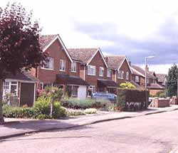
 Beech Avenue Built in the Tree Estate, much of whichwas built in 1967 and 1968, these houses are among the very few in Bingham without gabled roofs. In this part of the Tree estate access to the front of the houses is by means of a footpath, not a road. Photo: Peter Allen |
|
Rebuilding Bingham
A major component part of the slum clearance programme was the building of council housing to accommodate the people who would be made homeless by the demolition of their homes. Thus began the expansion of Bingham, with council houses in Chesterfield Avenue among the first to be built for this purpose.
In the late 1950s the County council delegated some of its planning powers to the RDCs, which meant that although the CC still made the overall plan, set priorities and defined the principles, the RDC had the power to implement the plan and set local plans.
Although Bingham was already expanding by the end of the nineteen fifties a surge in development came in the 1960s, when additional pressure was experienced in Bingham by private developers to build more housing. Bingham was seen to be a better place to live than the suburbs of Nottingham, even by those who worked in Nottingham. Bingham RDC was not unsympathetic to this development, because it fitted with their and the County Council’s plan to concentrate development in Bingham. The Crown took advantage of this opportunity and proposed areas for housing such as the Holme Farm and Church Farm estates. Both have been subjected to flooding. The railway line embankment inhibited drainage until major culverts were driven under it. In the 1950s and 1960s flooding was caused by such simple acts as a farmer as far away as Sibthorpe partly blocking the Northing Drain to divert water from it to use on his farm.
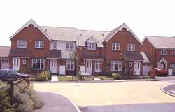 Nightingale Road Built between the by-pass and the Grantham Road these are some of nearly 300 houses added to Bingham in 2000 and 2001. They are mostly detached house of the type sometimes called Executive housing. Photo: Peter Allen |
The expansion of Bingham continues still, with the population tripling since 1950.
Re-housing the squatters
One unusual influence on the planning was the existence of squatters on Langar airfield. Immediately after the war there was an acute nationwide shortage of housing and many people, otherwise homeless, occupied buildings on abandoned airfields. This nationwide movement involved tens of thousands of people, particularly near towns that had been heavily bombed. In Langar there were around 40 to 50 families. The RDC improved some of the accommodation there for the occupiers, but decided in the medium term to re-house them in the villages from which they originally came. Those in poor squatter accommodation at Langar were re-housed first; others followed throughout the fifties and early sixties. Most came to Bingham.
For maps of Bingham showing how it was in 1835 and how it has changed
since then click on:
Sanderson’s map
Detailed accounts of the streets in the core
of Bingham show how they have evolved and can be accessed by clicking
on the following:
Market Place and Station Street
Market Street, Union and Needham streets
Moor Lane, Newgate Street, Kirkhill, Fairfield
Street and School Lane
Long Acre and Long Acre East
The Banks and Fisher Lane
Church Street, East Street and Cherry
Street