
![]()
WORLD WAR II
WARTIME BUILDINGS AND INSTALLATIONS
The proximity of Newton Airfield, about 2 km to the north west put Bingham within the defensive ring around it, with searchlights, gun emplacements, pill boxes and other installations built within the boundary of the town. But Bingham responded to the outbreak of war in many other ways, particularly because of its importance as a food producer, and for strategic reasons because of its geographical position with regard to roads and railways.
Most of the physical evidence of wartime installations has now gone, but a survey carried out by two BHTA members in 1996 identified the whereabouts of many of them. What is known about these installations is given here:
Newton Airfield
Buildings and installations
When you access Wartime installations in Bingham you will need a PDF reader on your computer to see the slides made from a photographic record largely made in the 1970s.
NEWTON AIRFIELD
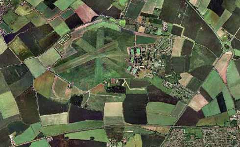
Aerial view of Newton Airfield showing it in its modern form. Note the Margidunum roundabout on the right hand side; the railway line is along the south side. Photo: Altavista
The Second World War came early to Bingham when work started on a new airfield 2 km to the north west, near the village of Newton. Construction of Newton Airfield started in 1936 (POPUP 1). Stan Wright, whose father farmed 28 acres of the affected land, recalls: “ My father secured a contract to provide 6 horses & carts on a daily basis for carrying materials on the airfield site. Two of the horses & carts belonged to us, whilst the other four were provided by local farmers at £1 per day; a lot of money in those days”. Newton was, and still is, an all-grass airfield so was limited in its use as a Bomber base, the surface not being able to support heavy loads. Because of this limitation the first aircraft based there, Wellingtons & Hampdens, could not take off with a full bomb-load. The airfield was prone to becoming “waterlogged” during wet spells, and so in 1940 it became the home of 16 S. Flying Training School, a flying school mainly for Polish airmen, operating Magisters, Tiger Moths, Oxfords and Ansons. Eventually the land farmed by Stan’s father was taken over for eight hardstanding dispersals and the Wrights moved on to Elston. In the early 50’s when Newton was the home of No. 12 Group, Fighter Command, the A.O.C. Air Marshal “Batchy” Atcherley used to operate a Meteor 8 jet fighter from the airfield; - landing on 2,000 yds of grass must have had its moments!!. The very first aircraft to land at Newton was a Whitley bomber, probably landing at about 60 m.p.h., a little different from the 115m.p.h. of the Meteor 8.
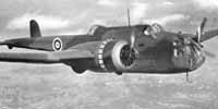
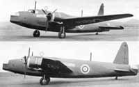
The Handley Page “Hampden” medium bomber with two Pegasus engines. Photo with permission of Jane’s Information Group
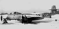
The Gloster Meteor 8 single-seat monoplane fighter with two Rolls Royce Derwent
jet engines. Photo: Eric Sharp
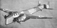
The Armstrong Whitworth “Whitley” heavy bomber with two Armstrong
Siddeley “Tiger” engines. Photo with permission of Jane’s
Information Group
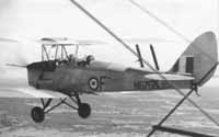
De Havilland 82A “Tiger Moth” two-seat light training biplane with
one 130h.p. Gipsy-Major engine
Photo: Eric Sharp
The Vickers “Wellington” long-range bomber with two Bristol “Pegasus”
engines.
Photo with permission of Jane’s Information Group
Newton airfield was protected by a ring of eight twin Bofor guns, each sited on a concrete slab with a double ring of barbed wire of about 30 yds. diameter surrounding them. It is believed that there was an outer ring of anti-aircraft guns but sites are not known, although there were searchlights sited on Crow field! The airfield “homer” and radio aerials were located on Chapel Lane, by the bridge over the Car Dyke , some 100yds north of the entrance to Moorbridge Road.There was also a “pillbox”. A local resident remembers the, by then, derelict huts on the site being used as changing rooms for football matches in the early 50’s.The playing area to be used depended upon which field was available for play i.e. not recently ploughed, or the corn had not yet been harvested!! Also in the early days Newton was used as a practice bombing range, and all houses within a mile of Newton had air-raid shelters provided by the Royal Air Force, presumably as a protection from German bombs, but in training anything can happen - and frequently does! Several of these air-raid shelters remain in local gardens. Further details of these can be found in the section following.
BUILDINGS AND INSTALLATIONS IN BINGHAM
Two BHTA members have compiled some notes on the physical aspects of wartime Bingham. David and Margaret Sibley originally produced the report in 1996 and lodged it with the RAF museum at Duxford. They have put together a record of sites in use for various activities together with a map of locations and a set of photographs taken in the 1970s. These photographs show some structures and buildings that are now lost.
Margaret produced a hand drawn map showing the positions of the various installations. The map predates certain changes in road layouts and reminds us of how Bingham was until relatively recently. Using the grid references provided BHTA has transferred the localities to the modern Ordnance Survey map. The features are marked in red numbers corresponding to the text below.
The map can be found by clicking here and can be viewed alongside the text that follows below. It is in pdf format and can be enlarged and scrolled using your pdf reader tools.
The text makes reference to various photographs. The PDF with David Sibley’s annotations and including photographs not referenced can be seen by clicking here. You will needa PDF reader to view it. It gives an interesting view of Bingham in the 1970s.
ONE SMALL VILLAGE AT WAR.
BINGHAM, NOTTINGHAMSHIRE - 1939 - 1945.
Margaret and David Sibley,
11th June 1996
At the outbreak of the war Bingham was a small village on the edge of the Vale of Belvoir. It was in a prime position with excellent road and rail facilities. One mile to the west is the road junction of the Foss Way (A46) and the Nottingham to Grantham road (A52). At that time there were two railway lines, the Nottingham to Grantham line with a station at the bottom of Station Street, Bingham, and the Nottingham to Melton Mowbray line, also with a station at the west end of the village (now dismantled.) These lines met at Saxondale Junction (SK686402) (19).
Because of its position a number of Military Installations were established.
R.A.F. Newton (1) was established
in 1936 1½ miles WNW of Bingham. (SK680415). One mile to the north of
Bingham a Wireless Station (2)
was situated (SK702410) and a Pillbox and Searchlight at SK702407 (3).
Three miles to the north was a small Army camp and Searchlight at Kneeton (east
of East Bridgford), (SK707448)
In the immediate vicinity of Bingham at the junction of the Foss Way and the Nottingham Road (SK688396) was an Army Camp which later on became an Italian Prisoner of War Camp (4); to the south of Nottingham Road was another Army Camp (17). There was a Tented Army Camp (14) situated at the East end of Bingham at Crow Field (the site of the possible deserted village of Crow Close) and there was also a Searchlight there. According to Mr. Hutton of Newgate Farm (6) in Bingham, there was a searchlight positioned at the top of Tythby Road (Formerly Mill Hill.)
For more information about the WWII installations at site at Crow Field click here.
Bingham was important for its Agricultural role during the war.
Near to the railway at the west end of Bingham, where the garage and Agricultural machinery suppliers (in 2010 Foley’s bookstore) now are, the War Agricultural machinery department had a depot and distribution centre. Mr. Hutton says that his farm was a dairy farm, but Mr.Higginbottom says that the large Blister hanger (18) was used for storing agricultural machinery. As the land round the farm is destined to be built on it is quite probable that this building and the other brick buildings there could be demolished. (Demolished February 1997).
On the west side of Tythby Road was a Land Army Camp (7), situated in an orchard, and on the opposite side of the road was a nissen hut (8). This was used as a classroom for the Toothill Secondary School in the 1960's.
In the centre of Bingham the Methodist Church Schoolroom was used as a NAAFI (11). In buildings at the back of Market Street (12) Boots the Chemists stored machinery. On the top of the Bingham Rural District Council Offices in the Market Place, was the Air Raid Siren (16)
We have managed to locate some of the air raid shelters and the sites of others.
There was one situated at the back of Market Street where Boots stored machinery
(12). According to Mrs. Ann Atwood
there were four situated in the Market Place (13),
but Mr. Alan Cabourne remembers only one at the east end of the Market Place.
The street wall of another adjoins Kirkhill House on School Lane (15),
and another is in the garden of Mr. and Mrs. Griffin at 'Halladale' (10),
10 The Banks. This shelter has been opened up at the opposite end to the entrance
and a new door inserted. Mr. Griffin said that the wall at this end was only
one brick thick so that in the case of emergency, and the occupants being unable
to get out of the shelter, the wall could be knocked out! This shelter was for
the use of two adjoining properties, and the shelter was sold to the householder
for £10 at the end of the war! Another shelter is situated at 2, Stanhope
Way. [Another is at 4 Long Acre – 20]
We would like to thank the following people for their help in compiling this report. Mrs. Ann Allwood, Mr. Alan Cabourne, Mr. and Mrs. Griffin, Mr. Derek Higginbottom and Mr. Hutton.