
![]()
The Banks looking west from the junction with Banks Paddock
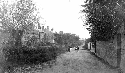
c.1900
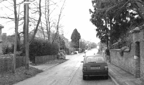
2003
Before the mid-1800s, The Banks consisted of a few scattered farms, cottage plots and orchards; the road would have been little more than a cart track. In 1840 John Doncaster built ‘Providence House’, later called ‘The Chestnuts’ then ‘Orchard Close’ and is currently known as ‘Long Acre House’. The brick wall on the right of both pictures marked the boundary of the plot and the gateway provided rear access. It now bounds the garden of a modern bungalow off Banks Paddock. By c.1900, when the picture was taken, and encouraged by the paving of the town roads in 1870, a wide range of dwellings was built. At the time, there were no pavements and even today there is only a continuous footpath on the north side of this narrow road. The 2003 picture gives the impression that the wall has been lowered; it is 20 bricks high in c.1900 and only 16 bricks high today. The reason for this is that the road surfacing and pavement have raised the ground level by about 12 inches.
On the corner of Fisher Lane, on the right just behind the two girls with the prams, Nos. 15 & 17 are semi-detached farm labourers’ cottages and next door, at No 19, a rather grand gothic style house, probably built for a professional man. It is thought that these date from c.1850. Due to the trees, none of these structures are visible in the photographs but their garden walls have not changed significantly over the intervening 100 years. The villas that can be seen on the left are ‘Banks’ and ‘Grove Cottages’ built in 1896 and so were fairly new when the photograph was taken. They were built by James Walker, of Walker Farm, who farmed land between Long Acre and The Banks. It is likely that he built these villas for well-to-do tradesmen and calling them ‘cottages’ was something of a conceit. As the gas mains would have been run to these new houses, a gas street lighting standard has also been installed opposite the end of Fisher Lane.
The main entrance to Toot Hill School and the Leisure Centre can be seen today on the left before the villas that are discernible through the trees. Judging by the form of the pollarded tree on the left of the 1900 picture, this is the same tree we see today that formed four trunks after pollarding ceased.
At the far end of the road on the left, in 1900, can be seen a barn or cottage which is now No. 10. Beyond this are, possibly, the roofs and chimneys of the small farmhouse and buildings that are now Nos.9 & 20 Tithby Road. Unfortunately, the trees and bushes in the 2003 picture make it difficult to be certain of this. For a view of The Banks, looking in the opposite direction from the same location, click here.