
![]()
Fairfield Street looking south from School Lane/Newgate Street junction
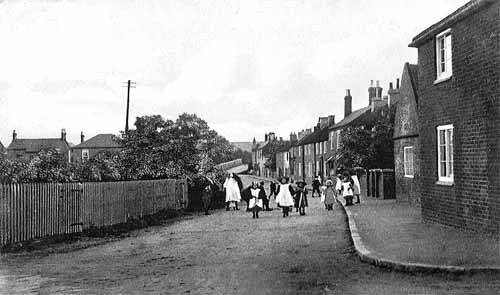
c.1908
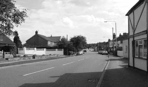
2003
The 2003 picture shows clearly
that Fairfield Street has been widened to accommodate the increase in traffic
since 1908. School children today would be very unwise to risk walking up
the middle of the road!
The wooden paling fence and bushes mark the boundary of Fair Close. The
taller trees indicate the position of the pond that is shown on the 1840
map but not on the 1883 map. There were complaints that the pond still hadn’t
been drained and filled in 1876, so it seems reasonable to assume the pond
disappeared around 1880. Certainly, the name ‘Pond
Street’ has been associated with Fairfield Street in the past
but it seems that the name change was not coincident with the pond being
drained. By the time the 1908 picture was taken, the present name was firmly
established. Beyond the hedge and trees, the roofs of Nos. 1 & 3 Long
Acre can be seen, these are now hidden by modern houses, dating from the
1920s to the 1950s, on the eastern side of the road.
On the western side most of the earlier building have survived. The house on the extreme right of the picture had undergone some changes even in 1908; the front door, opening straight onto the street has been bricked up and moved, probably, to its present position. This is just round the corner of the projecting building so it is not visible in the photograph. It is possible that the gable end, with a single window, seen beyond this point, was originally a separate cottage or barn. It is now part of the present house No.23 ‘The Anchorage’ which has undergone considerable post-war re-modelling. The positions and sizes of the window openings and window frames in the main house have been radically altered and the rendering, mock half-timbering and ubiquitous white paint make it impossible to be certain of the details of the original building. The first floor room now has a dormer window.
The gable end and pitch roof of the ‘annex’
has been dismantled and replaced by a flat roof.
This now gives a view of the upper windows of No.19 ‘Blakeney’
that is set back from the line of the other frontages. No. 21 is totally
obstructed. All that can be seen of these houses in the 1908 photograph
are their front garden walls and brick piers with stone caps and the shrubs
in the garden of No. 19. These in turn obstruct all but the roof and chimneys
of No. 17 ‘Old Pond Cottage’, the first of the row of tradesmen’s
cottages, built in the 1850s. Next comes a cottage, No.
15, with a higher roof-line than the rest in the terrace. The facades
of Nos. 15 & 17 have been painted white. Today, there are a further
two cottages, No. 11 and No. 9 ‘Narnia’ but in 1908 there
was a further terrace of four small cottages and a double fronted house
set back from the
road.
Only the trees in its garden are visible in the 1908 picture. All were
demolished, in 1956, to form the car park for the White Lion and build
a pair of modern semi-detached houses, Nos. 5-7, set back from the road.
Originally, the cottages, Nos. 9 to 17 had a cart entrance giving access
to the rear of the properties. In recent years these have either been
converted to garages or extra rooms. In the case of No. 9, this had a
drive-way between it and the first terraced cottage. Since then, an extension
consisting of a garage and bedroom, which now forms the end of the terrace,
has been built over the driveway.
At the end of the road can be seen the White Lion pub and adjoining cottage, No. 1 Fairfield Street. For a better view of these, click here. Finally, the slope of Tithby Road, or Mill Hill Road, as it was previously known, and the boundary wall of No. 2 Long Acre, can be seen going up the Banks. On the skyline, there appear to be far more trees today than are evident in the 1908 picture.