
![]()
Parr’s Close and the Chettles
Parr’s Close
In April 1810 a William Chettle, farmer and grazier of Thornley, Cambridgeshire inherited a piece of land called Parr’s Close from John Chettle, grazier of Bingham. We do not know if this Parr’s Close has any relationship with the house known as Parr’s Close, number 21 Church Street.
The transfer was effected by indentures of lease and release dated respectively 4th and 11th April 1810. No measurement is given for the whole close. It would seem to be one of the pieces of land in Bingham not owned by the Earls of Chesterfield. We do not know if there is any connection between this and the house called Parr’s Close, 21 Church Street. Chettle did not erect a house here (see below).
 Sanderson’s
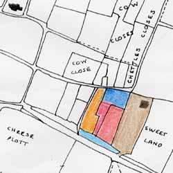
1835 map shows a single enclosure (a close) situated on
the north side of Long Acre (East) at its eastern end and
forming the entire western boundary of Cogley Lane, to about
where the railway is now. This could have been the full extent
of Parr’s Close, shown by the three coloured sections.
It would have been a plot of about five acres. Later maps
are more accurately proportioned than Sanderson’s and
show actual areas.
Sanderson’s
1835 map shows a single enclosure (a close) situated on
the north side of Long Acre (East) at its eastern end and
forming the entire western boundary of Cogley Lane, to about
where the railway is now. This could have been the full extent
of Parr’s Close, shown by the three coloured sections.
It would have been a plot of about five acres. Later maps
are more accurately proportioned than Sanderson’s and
show actual areas.
Chettle’s son, known as William Chettle Senior a farmer of Bingham, inherited the close at an unknown date.
The property description in the East Cottage deeds implies that at about the same time that he sold that plot, Chettle had sold a portion of Parr’s Close to the north, coloured blue on our deduced plan, to William Johnson and a portion to the west, coloured green and probably also measuring two roods, to William Sills. Part of his later became the plot now occupied by number 29.
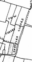
We do not know from the East Cottage deeds if Chettle sold other plots from the northern part of the close or if Johnson bought all of it. Examination of the 1841 Tithe map (shown right) rather suggests that he did, as the original close had by then been subdivided. The four new plots are named as ‘Chettle’s Closes’ although this description never seemed to get into any of the documents. The 1883 map, on which Parr’s Close is shown bounded in red, shows the four parcels of land clearly labelled – 325 (East Cottage), 324 (Oak Villa), 321 (Johnson’s which seems to have been extended sometime between 1837 and 1884) and 303.
The Chettles
There is no mention in this first document of any
house on the land, so it would have been just a field. This is confirmed
by the 1841 tithe map. In Whites Directory of 1832 William Chettle is
recorded as a Farmer of Long Acre. In 1841 Chettle rented 158 acres from
the Earl of Chesterfield; he was the fifth biggest farmer in Bingham at
that time.
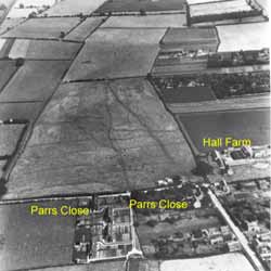
The deed documents for 51 Grantham Road suggest the Chettle farm house
was the now demolished Hall Farm - the area coloured brown on that plan,
overlooking Crow Close about where Rowan and Larch Closes now are. It
can be seen in the aerial photograph of Crow Close taken about 1950 (insert
image Hall Farm) ?. In the 1851 census John Chettle (now recorded as aged
52 - the 1841 census rounded ages down to nearest 5, so he would actually
have been 42) is recorded as having 160 acres, so they were a pretty substantial
farming family.
Chettles occupying one house in Long Acre noted in the census of 1841 were:
William aged 70 farmer
Mary his wife aged 70
John (son) aged 40 farmer
Elizabeth (John’s wife) 35
Three male servants (farm hands?) and two female servants.