
![]()
The Banks looking east from the junction with Banks Paddock
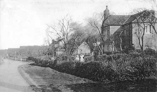
c.1900
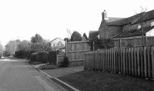
2003
Before the mid-1800s, The Banks consisted of a few scattered farms, cottage plots and orchards and the road would have been little more than a cart track. The picture, from a postcard that was posted on the 4th August 1906, is taken from just outside the southern boundary of Banks House built around 1850. The ‘gentry’ were moving their residences up the Banks, out of the town centre. However, this view of The Banks shows the rather poorer farmhouses and cottages that are more typical of the types of buildings that had been in this area since the 1700s.
The L-shaped cottage with a pan-tile roof on the right of the 1900 photograph still exists. The wing parallel to the road has been extended with a lean-to roof added along the frontage. Part of the original plot, nearest the camera, has been sold off. The high wooden fence in the 2003 picture marks the new boundary of a modern house built during the 1990s. The return of the hedge in the foreground in c.1900 suggests a path leading up the slope and today there is a footpath running beside the new house to Toot Hill School.
The early picture also shows a second footpath going to the right, just beyond the far boundary of the cottage. That is still there, leading to the Leisure Centre car park. On the opposite side, just behind the sign for Beetham Close, a 1990s development, Jebb’s Lane can be seen in the 2003 photograph and in 1900 this is suggested by the curve of the roadside bank on the extreme left. Most of the other cottages and out-building in 1900 have now been demolished to make way for a number of large post-war detached houses and bungalows. One of the 1900 cottages has survived as No. 50 The Banks but is hidden behind the modern house from this viewpoint. New housing has also been built on the site of the orchard and paddock with the paling fence that can be seen further down the road on the right in 1900. It is likely that this was a plum orchard for which the area was well known. Along the fence can be seen two upright poles, these may be additional gas lighting standards along the Banks.
At the end of The Banks, as it joins the Grantham Road, is the ‘new’ Cemetery, opened in 1888 when St. Mary’s churchyard became full. It is interesting to note that none of the trees in the Cemetery today are evident in the c.1900 postcard. It is possible that this detail has been lost in the old picture as another postcard of the cemetery, c.1920, does show some sizeable trees, possibly 20 to 30 years old if they were planted as part of the new cemetery site. The beech tree that can be seen at extreme left of the 2003 photograph is estimated to be 110-120 years old. As there is no sign of it in the 1900 postcard this suggests that it was a sapling at the time when the photo was taken. There is another intriguing detail on the skyline in 1900. There are, what appear to be, two long straight ridge roofs. These seem to be located approximately where the Police Station now stands on the Grantham Road but no record of such structures at this location has so far been found. A Clement Cooper, Builders Material Agent in Grantham Road is mentioned in the 1901 census and the 1908 directory but the exact location is not recorded.
Since the Second World War, the road has been widened and a run of kerbing has been build on the right but a continuous pavement is only on the north side of The Banks. For a view looking in the opposite direction from the same location, click here.