Why Bingham is where it is
In an ancient land like
ours the reasons why towns and villages are where they are
have long since been forgotten. In fact, there are not many
reasons why our forebears would have chosen any particular
site for a settlement. The most likely are that the site was
close to a supply of food or some other exploitable natural
resource. There would always have to be fresh water close
by and, for much of our early history, the site would have
to have been capable of being defended against aggressors.
Among the most likely natural resources
to influence the choice of location for a settlement are mineral
deposits. This is clearly evident now, when nearly all major
towns in Britain are sited either on coalfields or are ports
or are both. Most of them grew into being major urban areas
during the late eighteenth and nineteenth centuries when the
demand for coal to fuel the Industrial Revolution was at its
height, but nearly all of these places grew out of tiny villages
that were then already centres for the exploitation of various
minerals. There are Neolithic flint mines under Norwich. In
Cornwall nearly everywhere is situated by a copper or tin
mine, both of which have been mined there since the Bronze
Age. Many small towns and villages in Sussex have grown out
of Iron Age settlements adjacent to beds of iron ore that
our ancestors mined and smelted. Salt was mined under Droitwich
in Roman times and probably before. Coal is known to have
been mined throughout the English coalfield at least since
the twelfth century.
The link between other aspects of geology
and settlement, however, is not always as obvious as this.
Bingham is a good case in point.
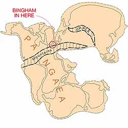
The story in Bingham begins
about 250 million years ago when all the continents of the
world were joined together in one giant supercontinent called
Pangaea. Britain was situated near the equatorial zone and
the landscape around where Bingham now is was a flat, arid
muddy plain with large, temporary lakes not far from the sea.
There was major river near by, the source of which was a range
of mountains where the Pyrenees now is as high as the Himalayas.
The river periodically flooded, covering the plain with deposits
of fine sand. With time the sea level gradually rose. The
course of the river shifted to the west and the plain was
periodically inundated with seawater, which evaporated leaving
salt and other minerals in the soil. Over time beds of the
salt called gypsum (calcium sulphate) formed.
|
|
All this can be
seen in the bedrock under Bingham. The red mudstones
that give rise to the heavy red-brown soils in gardens
along and to the south of Long Acre represent the flat
muddy plain and lake beds; the beds of skerry in the
fields south of the A52 show where the river overflowed
its banks and, beneath the surface north of the railway
line, are beds containing gypsum formed by the evaporation
of seawater.
The next important geological event
took place about 100,000 years ago when the last Ice
Age started. Bingham was never covered with ice, but
instead it was tundra with permanently frozen ground.
Only the surface unfroze during the summer months. The
Ice Age was as its coldest about 23,000 years ago, after
which the climate gradually warmed up and the ice began
to retreat northwards. Then, 10,000 years ago the ice
finally disappeared from Britain. After nearly 100,000
years during which it was frozen the underground water
in the rocks began to flow again. One consequence of
this was that the gypsum in the rocks in the land north
of the railway line was dissolved and washed away. Gradually,
this area subsided and filled with water, creating a
lake about two miles
long and nearly one mile wide. |
This lake was like a magnet to our prehistoric
ancestors. It offered fresh water for them to drink. There
were fish in it. Water fowls nested by and in it and big animals
would have come to it to drink in the evenings. Evidence that
Stone Age hunters did indeed come here some 14,000 years ago
is present in flint tools from that time that have been found
in the fields in the south of the parish. Gradually the lake
filled up to become marshland, but there are so many artefacts
from the Mesolithic and Neolithic periods that it is likely
that people were actually settled around the edge of the marshes
in those times.
The oldest known settlement is on Parson’s
Hill, believed to be Iron Age dating from about 600 BC. At
that time Parson’s Hill was an island probably surrounded
by marshland and linked to the mainland via a causeway on
the north side, where only a narrow strip of water bordered
the island.
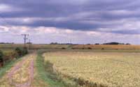
|
View of Parson’s Hill
looking north from the railway crossing at the end of
Cogley Lane. The flat area in the foreground is the site
of the post-glacial lake. The low Parson’s Hill
was always an island in the lake, a safe place for Iron
Age Britons to live. Parson’s Hill has been continuously
inhabited since then. |
It was an ideal place to live for the
warlike Britons of the time, easily protected on all sides.
When the Romans came and chose to build their settlement at
Margidunum it was almost certainly because of the proximity
of the marshes. The Roman villa at Carnarvon School is at
the south-eastern edge of the lake. By that time, though,
the edge of the marshes had begun to recede. This meant that
the peaty soils in the flat areas over what was once marsh
were available for agriculture with a little draining. It
also meant that there would be springs where the clay that
was laid down on the bed of the lake abutted against the sandstones
of the bedrock. The Romans, who lived in the villa at Carnarvon
School, had converted one such spring into a well that was
revealed during building work in 2002.
By early Medieval times it is likely
that the marshes had dried out and had no standing water,
which means that another source of fresh water had to be sought
by the villagers. Both the deserted Medieval village in Crow
Close and the present centre of Bingham are situated on relatively
high ground caused by rocks with beds of sandstone it them.
The sandstones hold water, which can be accessed fairly easily
in shallow wells. All houses in Bingham built before about
1920 had their own wells or access to a shared well.
Thus, the circle is complete. Gypsum,
deposited when Bingham was a desert was dissolved from the
bedrock at the end of an Ice Age nearly 250,000,000 years
later to create conditions that human beings found very amenable.
So they settled here, maybe as long as 14 thousand years ago,
and have been here ever since. |